Bethelridge | |
|---|---|
 Bethelridge Location within the state of Kentucky  Bethelridge Bethelridge (the United States) | |
| Coordinates: 37°14′1″N 84°45′30″W / 37.23361°N 84.75833°W | |
| Country | United States |
| State | Kentucky |
| County | Casey |
| Elevation | 1,138 ft (347 m) |
| Time zone | UTC-5 (Eastern (EST)) |
| • Summer (DST) | UTC-4 (EST) |
| ZIP codes | 42516 |
| GNIS feature ID | 507499[1] |
Bethelridge is an unincorporated community in southeastern Casey County, Kentucky, United States. Their post office was in operation from May 14, 1890, until it closed in November 2011.[2]
References
Municipalities and communities of Casey County, Kentucky, United States | ||
|---|---|---|
| City | 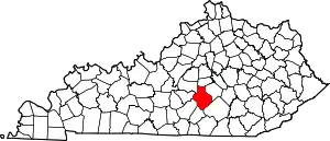 Location of Casey County, Kentucky | |
| Unincorporated Communities | ||
| Ghost Towns | ||
This article is issued from Wikipedia. The text is licensed under Creative Commons - Attribution - Sharealike. Additional terms may apply for the media files.