| Betsiamites River | |
|---|---|
 | |
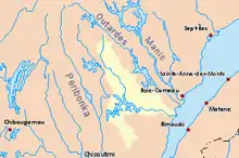 Drainage basin in yellow | |
| Location | |
| Country | Canada |
| Province | Quebec |
| Region | Saguenay–Lac-Saint-Jean, Côte-Nord |
| Physical characteristics | |
| Source | Lake Manouanis |
| • location | Mont-Valin |
| • coordinates | 50°45′10″N 70°19′20″W / 50.75278°N 70.32222°W |
| Mouth | Saint Lawrence River |
• location | Betsiamites FN Reserve |
• coordinates | 48°56′00″N 68°37′20″W / 48.93333°N 68.62222°W |
• elevation | 0 m (0 ft) |
| Length | 444 km (276 mi)to head of Manouanis River [1] |
| Basin size | 18,700 km2 (7,200 sq mi)[1] |
| Discharge | |
| • average | 340 m3/s (12,000 cu ft/s)[1] |
The Betsiamites (also called Bersimis) is a river of Côte-Nord, Quebec, Canada, which joins the Saint Lawrence River.
The 978 square kilometres (378 sq mi) Pipmuacan Reservoir, impounded by the Bersimis-1 Dam, is roughly halfway down its course.[2]
Hydro-electric facilities
There are two hydro-electric power stations and dams on the Betsiamites, owned by Hydro-Québec:
- Bersimis-1 generating station: 1,125 MW; constructed in 1956
- Bersimis-2 generating station: 845 MW; constructed in 1959
References
- 1 2 3 Natural Resources Canada, Atlas of Canada - Rivers Archived April 4, 2007, at the Wayback Machine
- ↑ Natural Resources Canada, Atlas of Canada - Lakes Archived 2007-04-10 at the Wayback Machine
External links
This article is issued from Wikipedia. The text is licensed under Creative Commons - Attribution - Sharealike. Additional terms may apply for the media files.