Beverstedt | |
|---|---|
 Coat of arms | |
Location of Beverstedt within Cuxhaven district 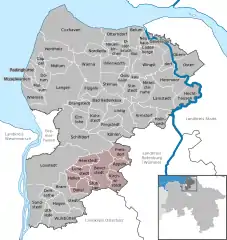 | |
 Beverstedt 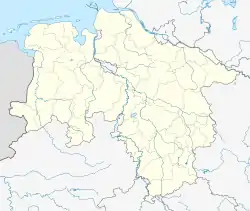 Beverstedt | |
| Coordinates: 53°26′06″N 08°49′09″E / 53.43500°N 8.81917°E | |
| Country | Germany |
| State | Lower Saxony |
| District | Cuxhaven |
| Disbanded | 1 November 2011 |
| Subdivisions | 9 municipalities |
| Area | |
| • Total | 197.60 km2 (76.29 sq mi) |
| Elevation | 10 m (30 ft) |
| Population (2010-12-31)[1] | |
| • Total | 13,694 |
| • Density | 69/km2 (180/sq mi) |
| Time zone | UTC+01:00 (CET) |
| • Summer (DST) | UTC+02:00 (CEST) |
| Postal codes | 27616 |
| Dialling codes | 04747, 04748, 04749 |
| Vehicle registration | CUX |
| Website | www.beverstedt.de |
Beverstedt is a former Samtgemeinde ("collective municipality") in the district of Cuxhaven, in Lower Saxony, Germany. Its seat was in the town Beverstedt. It was disbanded on 1 November 2011, when its constituent municipalities merged into the municipality Beverstedt.
The Samtgemeinde Beverstedt consisted of the following municipalities:
- Appeln
- Beverstedt
- Bokel
- Frelsdorf
- Heerstedt
- Hollen
- Kirchwistedt
- Lunestedt
- Osterndorf
- Stubben
References
This article is issued from Wikipedia. The text is licensed under Creative Commons - Attribution - Sharealike. Additional terms may apply for the media files.