Bhojpur
District ( Khikamakchha District)
भोजपुर जिल्ला ( खिकामाक्छा जिल्ला) | |
|---|---|
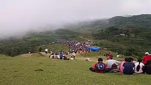 Chandi Bazar: A famous spot of Kirat Rai Ubhauli festival in Balankha | |
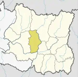 Location of Bhojpur district | |
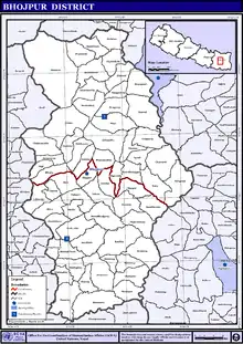
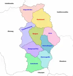 Political division of Bhojpur | |
| Coordinates: 27°10′21″N 87°02′53″E / 27.17250°N 87.04806°E | |
| Country |  Nepal Nepal |
| Province | Koshi Province |
| Admin HQ. | Bhojpur |
| Municipality | |
| Government | |
| • Type | Coordination committee |
| • Body | DCC, Bhojpur |
| • Head | Mr. Laxman Khadka |
| • Deputy-Head | Mrs. Anisha Khadka |
| • Parliamentary constituencies | 1 |
| • Provincial constituencies | 2 |
| Area | |
| • Total | 1,507 km2 (582 sq mi) |
| Highest elevation | 4,153 m (13,625 ft) |
| Lowest elevation | 153 m (502 ft) |
| Population (2011) | |
| • Total | 182,459 |
| • Households | 39,393 |
| Demographics | |
| • Ethnic groups | |
| • Female ♀ | 53% |
| • Male ♂/100 female | 89.96 |
| Human Development Index | |
| • Income per capita (US dollars) | $999 |
| • Poverty rate | 24.4 |
| • Literacy | 69% |
| • Life Expectancy | 68.3 |
| Time zone | UTC+05:45 (NPT) |
| Postal Codes | 57000, 57001..., 57015 |
| Telephone Code | 029 |
| Main Language(s) | Nepali, Rai, Tamang |
| Major highways | Mid-Hills Highway |
| Website | ddcbhojpur |
Bhojpur District (Nepali: भोजपुर जिल्ला [bʱod͡zpur] ⓘ) is one of 14 districts of Koshi Province of eastern Nepal. The district's area is 1,507 km2 with a population of 182,459 (2011).[1] The administrative center is Bhojpur. It is surrounded by Dhankuta and Sankhuwasabha in the east, Khotang in the west, again Sankhuwasabha in north-east and Solukhumbu in the north-west and Udayapur in the South.
Etymology
According to the District Coordination Committee Bhojpur, this place was named for the Himalayan birch (Betula utilis. However its original name was Khikamakchha , Nepali भोजपत्र bhojpatra), which was found here in large quantities.[2] Pur means 'city'.
Geography and climate
Classified as a Hill District, Bhojpur actually spans five of Nepal's eight climate zones.[3] 3% of the district's area is below 300 meters elevation in the Lower Tropical zone and 31% is Upper Tropical from 300 to 1,000 meters. 50% of the land area belongs to the Subtropical Zone between 1,000 and 2,000 meters and 15% is Temperate (2,000 to 3,000 meters). 2% rises higher into the Subalpine Zone.
| Climate Zone[3] | Elevation Range | % of Area |
|---|---|---|
| Lower Tropical | below 300 meters (1,000 ft) | 2.7% |
| Upper Tropical | 300 to 1,000 meters 1,000 to 3,300 ft. |
30.5% |
| Subtropical | 1,000 to 2,000 meters 3,300 to 6,600 ft. |
49.8% |
| Temperate | 2,000 to 3,000 meters 6,400 to 9,800 ft. |
15.1% |
| Subalpine | 3,000 to 4,000 meters 9,800 to 13,100 ft. |
1.7% |
Divisions
Bhojpur is divided into two urban and seven rural municipalities:
| No. | Type | Name | Population (2011) | Area | Wards | Website |
|---|---|---|---|---|---|---|
| 1 | Urban | Bhojpur | 28,107 | 159.51 | 12 | |
| 2 | Urban | Shadanand | 31,612 | 241 | 14 | |
| 3 | Rural | Hatuwagadhi | 20,404 | 142.61 | 9 | |
| 4 | Rural | Ramprasad Rai | 18,848 | 158.83 | 8 | |
| 5 | Rural | Aamchok | 18,720 | 184.89 | 10 | |
| 6 | Rural | Tyamke Maiyunm | 17,911 | 173.41 | 9 | |
| 7 | Rural | Arun Gaunpalika | 17,687 | 154.76 | 7 | |
| 8 | Rural | Pauwadungma | 15,394 | 118.86 | 6 | |
| 9 | Rural | Salpasilichho | 13,111 | 193.33 | 6 | |
| District | Bhojpur | 182,459 | 1,507 | 81 |
Towns and villages (former VDC)
- Aangtep
- Annapurna
- Baikunthe
- Balankha
- Basikhora
- Basingtharpu
- Bastim
- Bhaisipankha
- Bhubal
- Bhulke
- Bokhim
- Bhojpur
- Boya
- Champe
- Changre
- Charambi
- Chaukidanda
- Chhinamakhu
- Dalgaun
- Deurali
- Dewantar
- Dhodalekhani
- Dobhane
- Dummana
- Gogane
- Gupteshwar
- Hasanpur
- Helauchha
- Homtang
- Jarayotar
- Kimalung
- Keurepani
- Khairang
- Khartimchha
- Khatamma
- Khawa
- Kot
- Kudak Kaule
- Kulunga
- Lekharka
- Mane Bhanjyang
- Mulpani
- Nagi
- Nepaledada
- Okhre
- Pangcha
- Patle Pani
- Pawala
- Pyauli
- Ranibas
- Sangpang
- Sano Dumba
- Shadanand Municipality
- Shyamsila
- Siddheshwar
- Sindrang
- Syamsila
- Taksar
- Thidingkha
- Thulo Dumba
- Timma
- Tiwari Bhanjyang
- Tunggochha
- Yaku
- Yangpang
Demographics
| Census year | Pop. | ±% p.a. |
|---|---|---|
| 1981 | 192,689 | — |
| 1991 | 198,784 | +0.31% |
| 2001 | 203,018 | +0.21% |
| 2011 | 182,459 | −1.06% |
| 2021 | 158,991 | −1.37% |
| Sources:[4] | ||
At the time of the 2011 Nepal census, Bhojpur District had a population of 182,459.
As their first language, 49.0% spoke Nepali, 19.7% Bantawa, 7.5% Tamang, 4.5% Newar, 3.4% Magar, 3.0% Dungmali, 2.4% Kulung, 2.0% Sampang, 1.5% Sherpa, 1.4% Rai, 1.2% Chamling, 0.7% Nachhiring, 0.3% Bhujel, 0.3% Gurung, 0.3% Mewahang, 0.3% Thulung, 0.2% Koi, 0.2% Maithili, 0.1% Bhojpuri, 0.1% Ghale, 0.1% Khaling, 0.1% Limbu, 0.1% Sanskrit, 0.1% Thangmi, 0.1% Yakkha and 0.9% other languages.[6]
Ethnicity/caste: 32.1% were Rai, 19.7% Chhetri, 9.5% Tamang, 8.0% Newar, 6.2% Hill Brahmin, 4.9% Kami, 4.7% Magar, 2.6% Damai/Dholi, 2.3% Sarki, 2.2% Kulung, 1.7% Gharti/Bhujel, 1.7% Sherpa, 0.9% Sanyasi/Dasnami, 0.6% Nachhiring, 0.4% Gurung, 0.3% Ghale, 0.2% Majhi, 0.2% Mewahang Bala, 0.1% Bantawa, 0.1% Kumal, 0.1% Limbu, 0.1% Samgpang, 0.1% Sunuwar, 0.1% Thakuri, 0.1% Thami, 0.1% Thulung, 0.1% Yakkha, 0.1% Yamphu and 0.3% others.[7]
Religion: 53.3% were Hindu, 31.5% Kirati, 14.2% Buddhist, 0.5% Christian, 0.2% Prakriti and 0.2% others.[8]
Literacy: 69.1% could read and write, 2.5% could only read and 28.3% could neither read nor write.[9]
2015 Nepal earthquake
The district was affected by an earthquake on 25 April 2015.[10]
See also
References
- ↑ "National Population and Housing Census 2011(National Report)" (PDF). Central Bureau of Statistics. Government of Nepal. November 2012. Archived from the original (PDF) on 18 April 2013. Retrieved 1 November 2012.
- ↑ संक्षिप्त परिचय. District Coordination Committee Office जिल्ला समन्वय समितिको कार्यालय. Retrieved 25 January 2020.
- 1 2 Lillesø, J-P.B.; T.B. Shrestha; L.P. Dhakal; R.P. Nayaju; R. Shrestha (2005). The Map of Potential Vegetation of Nepal: a forestry/agroecological/biodiversity classification system (PDF). Development and Environment Series no. 2-2005 and CFC-TIS Document Series No. 110. Center for Skov, Landskab og Planlægning/Københavns Universitet. ISBN 87-7903-210-9. Retrieved 22 November 2013.
- ↑ "Nepal: Provinces and Districts". www.citypopulation.de.
- 1 2 "NepalMap profile: bhojpur". NepalMap. Retrieved 16 July 2022.
- ↑ NepalMap Language
- ↑ NepalMap Caste
- ↑ NepalMap Religion
- ↑ NepalMap Literacy
- ↑ Bob Kasarda (13 June 2015). "Nepal family finds starting over tough in wake of earthquake". NWI Times. Retrieved 21 June 2015.
Further reading
- "Districts of Nepal". Statoids.
External links
Places adjacent to Bhojpur District, Nepal | ||||||||||||||||
|---|---|---|---|---|---|---|---|---|---|---|---|---|---|---|---|---|
| ||||||||||||||||


Headquarter: Bhojpur | ||
| Urban Municipality | | |
| Rural Municipality | ||
For former VDCs See here
| ||
