Black Sands, Hawaii | |
|---|---|
 Black Sands | |
| Coordinates: 19°24′43″N 154°57′37″W / 19.41194°N 154.96028°W | |
| Country | |
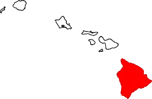
| State | Hawaii |
| County | Hawaii |
| Area | |
| • Total | 0.54 sq mi (1.40 km2) |
| • Land | 0.54 sq mi (1.40 km2) |
| • Water | 0.00 sq mi (0.00 km2) |
| Elevation | 880 ft (270 m) |
| Population (2020) | |
| • Total | 416 |
| • Density | 770.37/sq mi (297.44/km2) |
| Time zone | UTC-10 (Hawaii–Aleutian Time Zone) |
| ZIP Code | 96778 (Pahoa) |
| Area code | 808 |
| FIPS code | 15-02832 |
| GNIS feature ID | 2806891[2] |
Black Sands is an unincorporated community and census-designated place (CDP) in Hawaii County, Hawaii, United States. It is bordered to the southeast, across Hawaii Route 130, by the community of Seaview.
Black Sands was first listed as a CDP prior to the 2020 census.
Demographics
| Census | Pop. | Note | %± |
|---|---|---|---|
| 2020 | 416 | — | |
| U.S. Decennial Census[3] | |||
References
- ↑ "2020 U.S. Gazetteer Files". United States Census Bureau. Retrieved December 18, 2021.
- 1 2 "Black Sands Census Designated Place". Geographic Names Information System. United States Geological Survey, United States Department of the Interior.
- ↑ "Census of Population and Housing". Census.gov. Retrieved June 4, 2016.
This article is issued from Wikipedia. The text is licensed under Creative Commons - Attribution - Sharealike. Additional terms may apply for the media files.