Blairmore
| |
|---|---|
 Blairmore Village Hall and shops. | |
 Blairmore Location within Argyll and Bute | |
| OS grid reference | NS 19200 82500 |
| Council area |
|
| Lieutenancy area |
|
| Country | Scotland |
| Sovereign state | United Kingdom |
| Post town | DUNOON, ARGYLL |
| Postcode district | PA23 |
| Dialling code | 01369 |
| UK Parliament |
|
| Scottish Parliament |
|
Blairmore is a village located on the Cowal peninsula in Argyll and Bute, Scotland. Blairmore lies within the Loch Lomond and The Trossachs National Park.[1] It is situated on the western shore of Loch Long and around 1 mile (1.6 km) north of Strone. The village was largely built during the Victorian era and has a small wooden pier which dates to 1855.[2][3]
Gallery
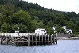 Blairmore Pier
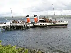 Paddle steamer Waverley about to leave Blairmore pier
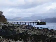 Blairmore Pier
 Blairmore Pier - geograph.org.uk - 758676
References
- ↑ "Archived copy" (PDF). Archived from the original (PDF) on 14 June 2019. Retrieved 17 January 2017.
{{cite web}}: CS1 maint: archived copy as title (link) - ↑ "History of Blairmore in Argyll and Bute | Map and description". Visionofbritain.org.uk. Retrieved 5 April 2012.
- ↑ "Blairmore Pier, Near Strone". The Glasgow Herald. 11 July 1855. p. 1. Retrieved 5 April 2012.
External links
- Map sources for Blairmore, Argyll
Wikimedia Commons has media related to Blairmore, Argyll and Bute.
This article is issued from Wikipedia. The text is licensed under Creative Commons - Attribution - Sharealike. Additional terms may apply for the media files.