Boleradice | |
|---|---|
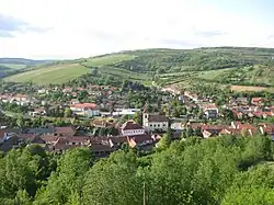 Boleradice from the Paseky hill | |
 Flag  Coat of arms | |
 Boleradice Location in the Czech Republic | |
| Coordinates: 48°58′0″N 16°48′50″E / 48.96667°N 16.81389°E | |
| Country | |
| Region | South Moravian |
| District | Břeclav |
| First mentioned | 1141 |
| Area | |
| • Total | 12.11 km2 (4.68 sq mi) |
| Elevation | 205 m (673 ft) |
| Population (2023-01-01)[1] | |
| • Total | 923 |
| • Density | 76/km2 (200/sq mi) |
| Time zone | UTC+1 (CET) |
| • Summer (DST) | UTC+2 (CEST) |
| Postal code | 691 12 |
| Website | www |
Boleradice is a market town in Břeclav District in the South Moravian Region of the Czech Republic. It has about 900 inhabitants.
History
The first written mention of Boleradice is from 1141.[2]
References
- ↑ "Population of Municipalities – 1 January 2023". Czech Statistical Office. 2023-05-23.
- ↑ "Historie obce" (in Czech). Obec Boleradice. Retrieved 2021-11-23.
External links
Wikimedia Commons has media related to Boleradice.
This article is issued from Wikipedia. The text is licensed under Creative Commons - Attribution - Sharealike. Additional terms may apply for the media files.