Bonita, Kansas | |
|---|---|
 Bonita  Bonita | |
| Coordinates: 38°48′40″N 94°48′53″W / 38.81111°N 94.81472°W[1] | |
| Country | United States |
| State | Kansas |
| County | Johnson |
| Elevation | 1,099 ft (335 m) |
| Time zone | UTC-6 (CST) |
| • Summer (DST) | UTC-5 (CDT) |
| FIPS code | 20-07950 [1] |
| GNIS ID | 479559 [1] |
Bonita is an unincorporated community in Johnson County, Kansas, United States,[1] and part of the Kansas City metropolitan area. It is located at 38°48′40″N 94°48′53″W / 38.81111°N 94.81472°W.[1]
History
Bonita is a Spanish name meaning "beautiful".[2]
Bonita had a post office from 1880 until 1934.[3]
References
- 1 2 3 4 5 6 "Bonita, Kansas", Geographic Names Information System, United States Geological Survey, United States Department of the Interior
- ↑ Blair, Ed (1915). History of Johnson County, Kansas. Standard Publishing Company. pp. 178.
- ↑ "Kansas Post Offices, 1828–1961". Kansas Historical Society. Retrieved June 12, 2014.
Further reading
External links
Municipalities and communities of Johnson County, Kansas, United States | ||
|---|---|---|
| Cities | 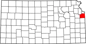 Map of Kansas highlighting Johnson County | |
| Unincorporated communities | ||
| Townships | ||
| Footnotes | ‡This community also has portions in an adjacent county or counties. | |
This article is issued from Wikipedia. The text is licensed under Creative Commons - Attribution - Sharealike. Additional terms may apply for the media files.