Branchville, Georgia | |
|---|---|
 Branchville  Branchville | |
| Coordinates: 31°09′02″N 84°18′56″W / 31.1506°N 84.3156°W | |
| Country | United States |
| State | Georgia |
| County | Mitchell |
| Area | |
| • Total | 98.5 sq mi (255 km2) |
| Elevation | 140 ft (40 m) |
| Population (2007) | |
| • Total | 1,090 |
| • Density | 11/sq mi (4/km2) |
| Time zone | UTC-5 (Eastern (EST)) |
| • Summer (DST) | UTC-4 (EDT) |
| Area code | 229 |
Branchville is an unincorporated community located in Mitchell County, Georgia, United States.[1]
History
A variant name was "Faircloth".[1] The present name is after Colonel W. Branch, a pioneer citizen.[2]
References
- 1 2 U.S. Geological Survey Geographic Names Information System: Branchville
- ↑ Krakow, Kenneth K. (1975). Georgia Place-Names: Their History and Origins (PDF). Macon, GA: Winship Press. p. 24. ISBN 0-915430-00-2.
Municipalities and communities of Mitchell County, Georgia, United States | ||
|---|---|---|
| Cities | 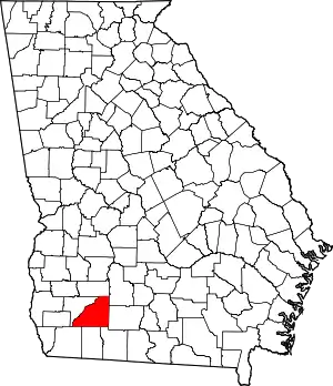 Map of Georgia highlighting Mitchell County | |
| Town | ||
| Unincorporated communities | ||
| Footnotes | ‡This populated place also has portions in an adjacent county or counties | |
This article is issued from Wikipedia. The text is licensed under Creative Commons - Attribution - Sharealike. Additional terms may apply for the media files.