| Brenta Spire, The Bugaboos | |
|---|---|
 Brenta Spire | |
| Highest point | |
| Elevation | 2,958 m (9,705 ft)[1] |
| Prominence | 313 m (1,027 ft)[1] |
| Coordinates | 50°45′36″N 116°46′20″W / 50.76000°N 116.77222°W[1] |
| Geography | |
| Location | British Columbia, Canada |
| District | Kootenay Land District |
| Parent range | Purcell Mountains, Columbia Mountains |
| Topo map | NTS 82K10 Howser Creek |
| Geology | |
| Mountain type | Granite |
| Climbing | |
| First ascent | 1938 M. Schnellbacher; L. Coveney; S. Hendricks; P. Olton; P. Prescott[1] |
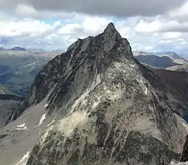
Brenta Spire is a peak in the Purcell Mountains of the Columbia Mountains in southeastern British Columbia, Canada. Brenta Spire is the highest and middle of the three granite spires on a cirque west of Cobalt Lake.[1]
Routes
The most common route is the south ridge, which can be climbed on its own or as part of the popular Brenta Spire - Northpost Spire traverse.[2]
References
- 1 2 3 4 5 "Brenta Spire". bivouac.com. Retrieved 2015-11-29.
- ↑ "Brenta Spire". mountainproject.com. Retrieved 2015-11-29.
External links
This article is issued from Wikipedia. The text is licensed under Creative Commons - Attribution - Sharealike. Additional terms may apply for the media files.