Browndale, Kansas | |
|---|---|
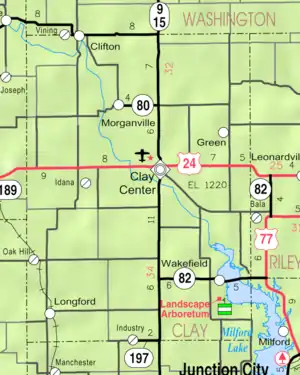 KDOT map of Clay County (legend) | |
 Browndale  Browndale | |
| Coordinates: 39°21′35″N 97°21′03″W / 39.35972°N 97.35083°W[1] | |
| Country | United States |
| State | Kansas |
| County | Clay |
| Elevation | 1,306 ft (398 m) |
| Population | |
| • Total | 0 |
| Time zone | UTC-6 (CST) |
| • Summer (DST) | UTC-5 (CDT) |
| Area code | 785 |
| FIPS code | 20-08665 [1] |
| GNIS ID | 484767 [1] |
Browndale is a ghost town in Clay County, Kansas, United States.[1] It is located at 39°21′35″N 97°21′03″W / 39.35972°N 97.35083°W.
History
Browndale was located on the Union Pacific Railroad.[2]
References
- 1 2 3 4 5 "Browndale, Kansas", Geographic Names Information System, United States Geological Survey, United States Department of the Interior
- ↑ "Geohydrology of Clay County". Kansas Geological Survey. Retrieved August 2, 2014.
External links
Municipalities and communities of Clay County, Kansas, United States | ||
|---|---|---|
| Cities | 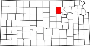 Map of Kansas highlighting Clay County | |
| Unincorporated communities | ||
| Ghost towns | ||
| Townships | ||
| Footnotes | †This community is designated a Census-Designated Place (CDP) by the United States Census Bureau. ‡This community also has portions in an adjacent county or counties. | |
This article is issued from Wikipedia. The text is licensed under Creative Commons - Attribution - Sharealike. Additional terms may apply for the media files.