Buclovany | |
|---|---|
Municipality | |
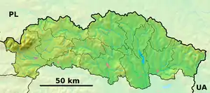 Buclovany Location of Buclovany in the Prešov Region  Buclovany Location of Buclovany in Slovakia | |
| Coordinates: 49°09′N 21°22′E / 49.150°N 21.367°E | |
| Country | |
| Region | Prešov |
| District | Bardejov |
| First mentioned | 1345 |
| Area | |
| • Total | 4.095 km2 (1.581 sq mi) |
| Elevation | 245 m (804 ft) |
| Population | |
| • Total | 230 |
| • Density | 56/km2 (150/sq mi) |
| Postal code | 086 43 (pošta Koprivnica) |
| Area code | 421-54 |
| Car plate | BJ |
| Website | www |
Buclovany is a village and municipality in Bardejov District in the Prešov Region of north-east Slovakia.
History
In historical records the village was first mentioned in 1345.
Geography
The municipality lies at an altitude of 245 metres and covers an area of 4.095 km². It has a population of about 230 people.
Genealogical resources
The records for genealogical research are available at the state archive "Statny Archiv in Presov, Slovakia"
- Roman Catholic church records (births/marriages/deaths): 1848-1908 (parish B)
- Greek Catholic church records (births/marriages/deaths): 1800-1895 (parish B)
- Lutheran church records (births/marriages/deaths): 1747-1895 (parish B)
See also
External links
- Official website

- https://web.archive.org/web/20071217080336/http://www.statistics.sk/mosmis/eng/run.html
- Surnames of living people in Buclovany
This article is issued from Wikipedia. The text is licensed under Creative Commons - Attribution - Sharealike. Additional terms may apply for the media files.