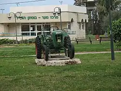
Bustan HaGalil
בֻּסְתַּן הַגָּלִיל | |
|---|---|
 | |
| Etymology: Orchard of the Galilee | |
 Bustan HaGalil  Bustan HaGalil | |
| Coordinates: 32°57′4″N 35°4′58″E / 32.95111°N 35.08278°E | |
| Country | |
| District | Northern |
| Council | Mateh Asher |
| Region | Western Galilee |
| Affiliation | Agricultural Union |
| Founded | 1948 |
| Founded by | Romanian Holocaust survivors |
| Population (2021)[1] | 1,305 |
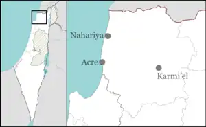
Bustan HaGalil (Hebrew: בֻּסְתַּן הַגָּלִיל or בוסתן הגליל lit. Orchard of the Galilee) is a moshav in the Western Galilee in northern Israel. Located near Acre, it falls under the jurisdiction of Mateh Asher Regional Council. As of 2021 its population was 1,305.[1]
History
It was founded in 1948 by Holocaust survivors from Romania and was located on the land of the depopulated Palestinian village of Al-Manshiyya, north of the village site.[2] The site had previously been used for the Sydney Smith Barracks, where the Armistice of Saint Jean d'Acre, which ended the Syria-Lebanon campaign of World War II in 1941, was signed.[3] [4] The name is symbolic, taken after the orchards in the area.[3]
After the 1948 Arab–Israeli War, residents of the moshav of Beit Yosef joined them.
References
- 1 2 "Regional Statistics". Israel Central Bureau of Statistics. Retrieved 22 February 2023.
- ↑ Khalidi, Walid (1992). All That Remains: The Palestinian Villages Occupied and Depopulated by Israel in 1948. Washington D.C.: Institute for Palestine Studies. p. 23. ISBN 0-88728-224-5.
- 1 2 Mapa's Concise Gazetteer of Israel (in Hebrew). Yuval El'azari (ed.). Tel-Aviv: Mapa Publishing. 2005. p. 55. ISBN 965-7184-34-7.
{{cite book}}: CS1 maint: others (link) - ↑ "Acre Pact". Time. 21 July 1941.
External links
- Bustan HaGalil Authority for Development of the Galilee (in Hebrew)