Campolieto | |
|---|---|
| Comune di Campolieto | |
.jpg.webp) | |
 Coat of arms | |
Location of Campolieto | |
 Campolieto Location of Campolieto in Italy 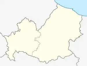 Campolieto Campolieto (Molise) | |
| Coordinates: 41°38′N 14°46′E / 41.633°N 14.767°E | |
| Country | Italy |
| Region | Molise |
| Province | Campobasso (CB) |
| Government | |
| • Mayor | Annamaria Palmiero |
| Area | |
| • Total | 24.2 km2 (9.3 sq mi) |
| Elevation | 735 m (2,411 ft) |
| Population | |
| • Total | 876 |
| • Density | 36/km2 (94/sq mi) |
| Demonym | Campoletani |
| Time zone | UTC+1 (CET) |
| • Summer (DST) | UTC+2 (CEST) |
| Postal code | 86040 |
| Dialing code | 0874 |
| Website | Official website |
Campolieto is a comune (municipality) in the Province of Campobasso in the Italian region Molise, located about 11 kilometres (7 mi) northeast of Campobasso.
Campolieto borders the following municipalities: Castellino del Biferno, Matrice, Monacilioni, Morrone del Sannio, Ripabottoni, San Giovanni in Galdo.
Twin towns — sister cities
Campolieto is twinned with:
 Arese, Italy (2006)
References
- ↑ "Superficie di Comuni Province e Regioni italiane al 9 ottobre 2011". Italian National Institute of Statistics. Retrieved 16 March 2019.
- ↑ All demographics and other statistics: Italian statistical institute Istat.
- ↑ "Popolazione Residente al 1° Gennaio 2018". Italian National Institute of Statistics. Retrieved 16 March 2019.
External links
This article is issued from Wikipedia. The text is licensed under Creative Commons - Attribution - Sharealike. Additional terms may apply for the media files.