Careiro da Várzea | |
|---|---|
 | |
.jpg.webp) Seal | |
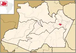 Location of the municipality inside Amazonas | |
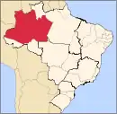
 Careiro da Várzea Location in Brazil | |
| Coordinates: 3°13′15″S 59°49′33″W / 3.22083°S 59.82583°W | |
| Country | |
| Region | North |
| State | |
| Area | |
| • Total | 2,631 km2 (1,016 sq mi) |
| Population (2020) | |
| • Total | 30,846 |
| • Density | 12/km2 (30/sq mi) |
| Time zone | UTC−4 (AMT) |
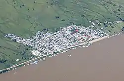
Careiro da Várzea is a municipality located in the Brazilian state of Amazonas. Its population was 30,846 (2020)[1] and its area is 2,631 km².[2] It lies on the south (right) bank of the Amazon opposite Manaus.
Careiro da Várzea is the terminus of the BR-319 road from southern Brazil. There is a ferry link to Manaus.
References
- ↑ IBGE 2020
- ↑ IBGE - "Archived copy". Archived from the original on 2008-06-11. Retrieved 2008-06-11.
{{cite web}}: CS1 maint: archived copy as title (link)
Capital: Manaus | ||||||||||||||
| Mesoregion Centro Amazonense |
|  | ||||||||||||
| Mesoregion Norte Amazonense |
| |||||||||||||
| Mesoregion Sudoeste Amazonense |
| |||||||||||||
| Mesoregion Sul Amazonense |
| |||||||||||||
This article is issued from Wikipedia. The text is licensed under Creative Commons - Attribution - Sharealike. Additional terms may apply for the media files.