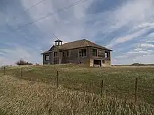
Carlyle is a ghost town in Wibaux County, Montana, United States, located approximately 1 to 1+1⁄2 miles west of the North Dakota border, sitting on a ranch, which incorporated the once agricultural town into grazing land. Some of the buildings once a part of the town are just foundations, however, a farmstead east of the town is still standing, with the school house, grain elevators and a couple of the homes inside the town. Southeast of the town of Carlyle is the cemetery. Carlyle had a population of 221 in the 1940s, with access to the Northern Pacific Railway branch out of Beach, North Dakota.
Climate
According to the Köppen Climate Classification system, Carlyle has a warm-summer humid continental climate, abbreviated "Dfb" on climate maps. The hottest temperature recorded in Carlyle was 107 °F (41.7 °C) on June 20, 1988, while the coldest temperature recorded was −39 °F (−39.4 °C) on December 21, 1989.[1]
| Climate data for Carlyle, Montana, 1991–2020 normals, extremes 1962–present | |||||||||||||
|---|---|---|---|---|---|---|---|---|---|---|---|---|---|
| Month | Jan | Feb | Mar | Apr | May | Jun | Jul | Aug | Sep | Oct | Nov | Dec | Year |
| Record high °F (°C) | 62 (17) |
69 (21) |
81 (27) |
91 (33) |
99 (37) |
107 (42) |
106 (41) |
105 (41) |
103 (39) |
92 (33) |
78 (26) |
65 (18) |
107 (42) |
| Mean maximum °F (°C) | 48.2 (9.0) |
51.0 (10.6) |
67.0 (19.4) |
77.3 (25.2) |
84.2 (29.0) |
90.6 (32.6) |
97.4 (36.3) |
97.7 (36.5) |
92.9 (33.8) |
79.7 (26.5) |
63.4 (17.4) |
50.7 (10.4) |
100.0 (37.8) |
| Mean daily maximum °F (°C) | 26.7 (−2.9) |
29.8 (−1.2) |
41.6 (5.3) |
53.0 (11.7) |
63.4 (17.4) |
73.0 (22.8) |
82.2 (27.9) |
82.4 (28.0) |
71.3 (21.8) |
55.0 (12.8) |
40.4 (4.7) |
29.6 (−1.3) |
54.0 (12.3) |
| Daily mean °F (°C) | 18.0 (−7.8) |
20.8 (−6.2) |
31.3 (−0.4) |
41.8 (5.4) |
52.0 (11.1) |
61.7 (16.5) |
69.4 (20.8) |
68.8 (20.4) |
58.8 (14.9) |
44.2 (6.8) |
31.1 (−0.5) |
21.2 (−6.0) |
43.3 (6.3) |
| Mean daily minimum °F (°C) | 9.4 (−12.6) |
11.7 (−11.3) |
21.0 (−6.1) |
30.5 (−0.8) |
40.6 (4.8) |
50.4 (10.2) |
56.6 (13.7) |
55.3 (12.9) |
46.2 (7.9) |
33.3 (0.7) |
21.8 (−5.7) |
12.8 (−10.7) |
32.5 (0.3) |
| Mean minimum °F (°C) | −17.7 (−27.6) |
−12.2 (−24.6) |
−3.0 (−19.4) |
13.8 (−10.1) |
27.1 (−2.7) |
38.6 (3.7) |
46.9 (8.3) |
42.9 (6.1) |
30.6 (−0.8) |
15.0 (−9.4) |
−0.3 (−17.9) |
−12.5 (−24.7) |
−23.1 (−30.6) |
| Record low °F (°C) | −38 (−39) |
−35 (−37) |
−26 (−32) |
−8 (−22) |
13 (−11) |
30 (−1) |
34 (1) |
31 (−1) |
15 (−9) |
−8 (−22) |
−23 (−31) |
−39 (−39) |
−39 (−39) |
| Average precipitation inches (mm) | 0.54 (14) |
0.58 (15) |
0.80 (20) |
1.64 (42) |
2.62 (67) |
2.53 (64) |
2.27 (58) |
1.37 (35) |
1.69 (43) |
1.41 (36) |
0.70 (18) |
0.60 (15) |
16.75 (427) |
| Average snowfall inches (cm) | 9.2 (23) |
9.6 (24) |
9.3 (24) |
5.8 (15) |
2.4 (6.1) |
0.0 (0.0) |
0.0 (0.0) |
0.0 (0.0) |
0.1 (0.25) |
3.7 (9.4) |
6.9 (18) |
8.3 (21) |
55.3 (140.75) |
| Average precipitation days (≥ 0.01 in) | 7.6 | 8.4 | 8.6 | 8.9 | 11.6 | 11.1 | 8.7 | 7.1 | 6.9 | 8.4 | 7.4 | 8.0 | 102.7 |
| Average snowy days (≥ 0.1 in) | 6.5 | 7.7 | 5.5 | 3.0 | 0.8 | 0.0 | 0.0 | 0.0 | 0.1 | 2.2 | 4.7 | 6.2 | 36.7 |
| Source 1: NOAA[2] | |||||||||||||
| Source 2: National Weather Service[1] | |||||||||||||
References
- 1 2 "NOAA Online Weather Data – NWS Glasgow". National Weather Service. Retrieved July 7, 2023.
- ↑ "U.S. Climate Normals Quick Access – Station: Carlyle 13 NW, MT". National Oceanic and Atmospheric Administration. Retrieved July 7, 2023.
External links
U.S. Geological Survey Geographic Names Information System: Carlyle, Montana
Municipalities and communities of Wibaux County, Montana, United States | ||
|---|---|---|
| Town | 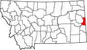 Wibaux County map | |
| Unincorporated communities | ||
46°39′18″N 104°04′34″W / 46.65500°N 104.07611°W