Caroebe | |
|---|---|
Municipality | |
| The Municipality of Caroebe | |
 Flag  Seal | |
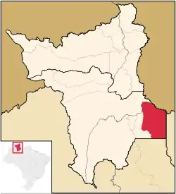 Location of Caroebe in the State of Roraima | |
| Coordinates: 00°53′02″N 59°41′45″W / 0.88389°N 59.69583°W | |
| Country | |
| Region | North |
| State | |
| Founded | 4 November 1994 |
| Government | |
| • Mayor | Argilson Raimundo Pereira Martins (PSDB) |
| Area | |
| • Total | 12,066 km2 (4,659 sq mi) |
| Elevation | 135 m (443 ft) |
| Population (2020 [1]) | |
| • Total | 10,383 |
| • Density | 0.48/km2 (1.2/sq mi) |
| Time zone | UTC−4 (AMT) |
| HDI (2000) | 0.661 – medium[2] |
| Website | caroebe.rr.gov.br |
Caroebe (Portuguese pronunciation: [kaɾoˈɛbi]) is a municipality located in the southeast of the state of Roraima in Brazil. Its population is 10,383 (as of 2020) and its area is 12,066 km². It is the easternmost municipality in Roraima and the only one to border the state of Pará. Careoebe became an independent municipality in 1994.[3]
Climate
Caroebe has a tropical rainforest climate (Af) with moderate rainfall from September to March and heavy rainfall from April to August.
| Climate data for Caroebe | |||||||||||||
|---|---|---|---|---|---|---|---|---|---|---|---|---|---|
| Month | Jan | Feb | Mar | Apr | May | Jun | Jul | Aug | Sep | Oct | Nov | Dec | Year |
| Mean daily maximum °C (°F) | 31.8 (89.2) |
31.5 (88.7) |
31.5 (88.7) |
31.3 (88.3) |
30.8 (87.4) |
30.8 (87.4) |
31.3 (88.3) |
31.9 (89.4) |
32.7 (90.9) |
33.0 (91.4) |
32.7 (90.9) |
32.5 (90.5) |
31.8 (89.3) |
| Daily mean °C (°F) | 26.8 (80.2) |
26.8 (80.2) |
26.9 (80.4) |
26.9 (80.4) |
26.6 (79.9) |
26.2 (79.2) |
26.4 (79.5) |
26.8 (80.2) |
27.7 (81.9) |
27.7 (81.9) |
27.8 (82.0) |
27.4 (81.3) |
27.0 (80.6) |
| Mean daily minimum °C (°F) | 21.9 (71.4) |
22.2 (72.0) |
22.4 (72.3) |
22.6 (72.7) |
22.5 (72.5) |
21.6 (70.9) |
21.6 (70.9) |
21.8 (71.2) |
22.7 (72.9) |
22.5 (72.5) |
22.9 (73.2) |
22.4 (72.3) |
22.3 (72.1) |
| Average rainfall mm (inches) | 86 (3.4) |
86 (3.4) |
111 (4.4) |
203 (8.0) |
285 (11.2) |
271 (10.7) |
259 (10.2) |
160 (6.3) |
117 (4.6) |
108 (4.3) |
74 (2.9) |
100 (3.9) |
1,860 (73.3) |
| Source: Climate-Data.org[4] | |||||||||||||
References
- ↑ IBGE 2020
- ↑ "Archived copy". Archived from the original on 2009-10-03. Retrieved 2009-12-17.
{{cite web}}: CS1 maint: archived copy as title (link) - UNDP - ↑ "Caroebe". IBGE (in Portuguese). Retrieved 15 April 2021.
- ↑ "Climate: Caroebe". Climate-Data.org. Retrieved August 14, 2020.
External links
- Official website (in Portuguese)
 Media related to Caroebe at Wikimedia Commons
Capital: Boa Vista | ||
| Boa Vista | 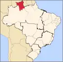 | |
| Nordeste de Roraima | ||
| Caracarai | ||
| Sudeste de Roraima | ||
This article is issued from Wikipedia. The text is licensed under Creative Commons - Attribution - Sharealike. Additional terms may apply for the media files.