Caruso, Kansas | |
|---|---|
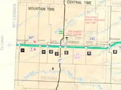 KDOT map of Sherman County (legend) | |
 Caruso  Caruso | |
| Coordinates: 39°20′19″N 101°48′56″W / 39.33861°N 101.81556°W[1] | |
| Country | United States |
| State | Kansas |
| County | Sherman |
| Elevation | 3,714 ft (1,132 m) |
| Time zone | UTC-7 (Mountain (MST)) |
| • Summer (DST) | UTC-6 (MDT) |
| Area code | 785 |
| FIPS code | 20-10875 [1] |
| GNIS ID | 484551 [1] |
Caruso is an unincorporated community in Sherman County, Kansas, United States.[1]
References
Further reading
External links
Municipalities and communities of Sherman County, Kansas, United States | ||
|---|---|---|
| Cities | 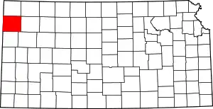 Map of Kansas highlighting Sherman County | |
| Unincorporated communities | ||
| Townships | ||
| Footnotes | †This community is designated a Census-Designated Place (CDP) by the United States Census Bureau. | |
This article is issued from Wikipedia. The text is licensed under Creative Commons - Attribution - Sharealike. Additional terms may apply for the media files.