Carwood | |
|---|---|
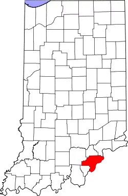 Clark County's location in Indiana | |
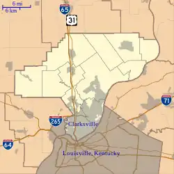 Carwood Location in Clark County | |
| Coordinates: 38°26′54″N 85°51′50″W / 38.44833°N 85.86389°W | |
| Country | United States |
| State | Indiana |
| County | Clark |
| Township | Carr |
| Elevation | 499 ft (152 m) |
| ZIP code | 47106 |
| FIPS code | 18-10630[1] |
| GNIS feature ID | 432202[2] |
Carwood is an unincorporated community in Carr Township, Clark County, Indiana.
History
It was previously known as Muddyfork or Muddy Fork after the stream that flows through the town.[3] The post office was established as Muddy Fork in 1858.[4] The post office was renamed Carwood in 1902, and it was discontinued in 1933.[5] Carwood was likely named for John Carr, a pioneer settler.[6]
Geography
Carwood is located at 38°26′54″N 85°51′50″W / 38.44833°N 85.86389°W.
References
- ↑ "U.S. Census website". United States Census Bureau. Retrieved January 31, 2008.
- ↑ "Carwood, Indiana". Geographic Names Information System. United States Geological Survey, United States Department of the Interior. Retrieved October 10, 2009.
- ↑ Andreas, Alfred Theodore (1876). "Clark County". Illustrated Historical Atlas of the State of Indiana. Chicago: Baskin, Forster & Company.
- ↑ "Clark County". Jim Forte Postal History. Retrieved August 30, 2014.
- ↑ "Clark County". Jim Forte Postal History. Archived from the original on September 3, 2014. Retrieved August 30, 2014.
- ↑ Baker, Ronald L. (October 1995). From Needmore to Prosperity: Hoosier Place Names in Folklore and History. Indiana University Press. p. 88. ISBN 978-0-253-32866-3.
...supposedly a coined name honoring General John Carr, an early settler...
Municipalities and communities of Clark County, Indiana, United States | ||
|---|---|---|
| Cities | Map of Indiana highlighting Clark County | |
| Towns | ||
| Townships | ||
| CDPs | ||
| Other communities | ||
| Footnotes | ‡This populated place also has portions in an adjacent county or counties | |
This article is issued from Wikipedia. The text is licensed under Creative Commons - Attribution - Sharealike. Additional terms may apply for the media files.