Castellanos | |
|---|---|
Populated centre | |
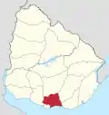
 Castellanos Location in Uruguay | |
| Coordinates: 34°22′40″S 55°57′25″W / 34.37778°S 55.95694°W | |
| Country | |
| Department | Canelones Department |
| Population (2004) | |
| • Total | 520 |
| Time zone | UTC -3 |
| Postal code | 90603 |
| Dial plan | +598 4313 (+4 digits) |
Castellanos is a populated centre in the Canelones Department of southern Uruguay.
Geography
Location
It is located on the intersection of Route 6 with Route 65, about 9 kilometres (5.6 mi) south of San Ramón.
Population
In 2011 Castellanos had a population of 520.[1]
| Year | Population |
|---|---|
| 1963 | 300 |
| 1975 | 418 |
| 1985 | 447 |
| 1996 | 509 |
| 2004 | 579 |
| 2011 | 520 |
Source: Instituto Nacional de Estadística de Uruguay[2]
References
- ↑ "Censos 2011 Canelones (flash plugin needed)". INE. 2012. Archived from the original on 7 September 2012. Retrieved 25 August 2012.
- ↑ "1963–1996 Statistics / C" (DOC). Instituto Nacional de Estadística de Uruguay. 2004. Retrieved 27 June 2011.
External links
Capital: Canelones | ||
| Towns and villages |
|  |
| Resorts of the Ciudad de la Costa | ||
| Sights |
| |
This article is issued from Wikipedia. The text is licensed under Creative Commons - Attribution - Sharealike. Additional terms may apply for the media files.