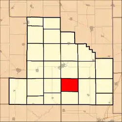
Clarksburg Township | |
|---|---|
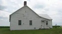 Clarksburg Schoolhouse, west of Clarksburg | |
 | |
.svg.png.webp) Location of Illinois in the United States | |
| Coordinates: 39°18′57″N 88°45′11″W / 39.31583°N 88.75306°W | |
| Country | United States |
| State | Illinois |
| County | Shelby |
| Organized | September 19, 1918 |
| Area | |
| • Total | 27.12 sq mi (70.2 km2) |
| • Land | 27.12 sq mi (70.2 km2) |
| • Water | 0 sq mi (0 km2) |
| Elevation | 623 ft (190 m) |
| Population (2010) | |
| • Estimate (2016)[1] | 392 |
| • Density | 14.8/sq mi (5.7/km2) |
| Time zone | UTC-6 (CST) |
| • Summer (DST) | UTC-5 (CDT) |
| ZIP code | XXXXX |
| Area code | 217 |
| FIPS code | 17-173-14637 |
Clarksburg Township is located in Shelby County, Illinois. As of the 2010 census, its population was 401 and it contained 177 housing units.[2]
Geography
According to the 2010 census, the township has a total area of 27.12 square miles (70.2 km2), all land.[2]
Adjacent townships
- Shelbyville Township (north)
- Richland Township (northeast)
- Prairie Township (east and southeast)
- Holland Township (south)
- Lakewood Township (west)
- Rose Township (northwest)
Demographics
| Census | Pop. | Note | %± |
|---|---|---|---|
| 2016 (est.) | 392 | [1] | |
| U.S. Decennial Census[3] | |||
References
- 1 2 "Population and Housing Unit Estimates". Retrieved June 9, 2017.
- 1 2 "Population, Housing Units, Area, and Density: 2010 - County -- County Subdivision and Place -- 2010 Census Summary File 1". United States Census. Archived from the original on February 12, 2020. Retrieved May 28, 2013.
- ↑ "Census of Population and Housing". Census.gov. Retrieved June 4, 2016.
External links
Municipalities and communities of Shelby County, Illinois, United States | ||
|---|---|---|
| Cities | Map of Illinois highlighting Shelby County | |
| Towns | ||
| Villages | ||
| Townships | ||
| CDPs | ||
| Other communities | ||
| Footnotes | ‡This populated place also has portions in an adjacent county or counties | |
This article is issued from Wikipedia. The text is licensed under Creative Commons - Attribution - Sharealike. Additional terms may apply for the media files.