Cleveland, South Carolina | |
|---|---|
 Cleveland post office | |
 Cleveland  Cleveland | |
| Coordinates: 35°04′20″N 82°31′38″W / 35.07222°N 82.52722°W | |
| Country | United States |
| State | South Carolina |
| County | Greenville |
| Elevation | 1,001 ft (305 m) |
| Population (2020) | |
| • Total | 1,347 |
| • Density | 19.5/sq mi (7.5/km2) |
| Time zone | UTC-5 (Eastern (EST)) |
| • Summer (DST) | UTC-4 (EDT) |
| ZIP code | 29635 |
| Area code | 864 |
| GNIS feature ID | 1221633[1] |
Cleveland is an unincorporated community in Greenville County, South Carolina, United States. Cleveland is located on U.S. Route 276 and South Carolina Highway 11, 8.7 miles (14.0 km) north-northwest of Travelers Rest. The population was 1,347 at the 2020 census.[2] Cleveland has a post office with ZIP code 29635, which opened on April 9, 1900.[3][4]
Demographics
As of the 2020 census, 1,347 people, 586 households and 438 families resided in Cleveland. 18.5% of the family households included children, while 68% were married couples with no children. 148 households were non-family; 5.7% of these consisted of a single householder with children while 7.5% consisted of a single householder with no children.
The racial demographic of the community was 96.1% white and 1.5% black, while all other races accounted for less than 1%. Hispanics and Latinos of any race accounted for 0.5% of the population.[2]
References
- 1 2 U.S. Geological Survey Geographic Names Information System: Cleveland, South Carolina
- 1 2 "People in Zip 29635 (Cleveland, SC)". Bestplaces.net. Retrieved March 25, 2022.
- ↑ United States Postal Service (2012). "USPS - Look Up a ZIP Code". Retrieved February 15, 2012.
- ↑ "Postmaster Finder - Post Offices by ZIP Code". United States Postal Service. Archived from the original on October 17, 2020. Retrieved August 6, 2013.
Municipalities and communities of Greenville County, South Carolina, United States | ||
|---|---|---|
| Cities | 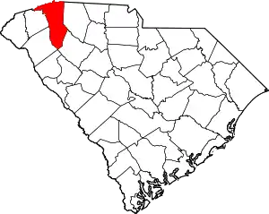 Map of South Carolina highlighting Greenville County | |
| CDPs | ||
| Other communities | ||
| Footnotes | ‡This populated place also has portions in an adjacent county or counties | |