| Coal River | |
|---|---|
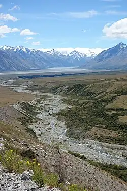 The Coal River flowing down towards Lake Tekapo with the Godley River in the background | |
| Location | |
| Country | New Zealand |
| Region | Canterbury |
| District | Mackenzie District |
| Physical characteristics | |
| Source | |
| • location | Two Thumb Range |
| Mouth | |
• location | Lake Tekapo |
• coordinates | 43°47′06″S 170°33′22″E / 43.785°S 170.556°E |
• elevation | 710m |
| Basin features | |
| Tributaries | |
| • right | Camp Stream |
Coal River is a river in Mackenzie District, Canterbury, New Zealand.[1] The river flows westward from the Two Thumb Range into the northern end of Lake Tekapo.
See also
References
- ↑ "Place name detail: Coal River". New Zealand Gazetteer. New Zealand Geographic Board. Retrieved 12 March 2020.
This article is issued from Wikipedia. The text is licensed under Creative Commons - Attribution - Sharealike. Additional terms may apply for the media files.