Coruripe | |
|---|---|
Municipality | |
| The Municipality of Coruripe | |
 Flag  Seal | |
| Nickname: "Land of the Caetés" | |
| Motto(s): "Trabalho e Progresso" ("Work and Progress") | |
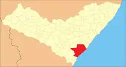 Location of Coruripe in the State of Alagoas | |
| Coordinates: 10°07′33″S 36°10′33″W / 10.12583°S 36.17583°W | |
| Country | |
| State | |
| Mesoregion | Leste Alagoano |
| Microregion | São Miguel dos Campos |
| Founded | 1850 |
| Government | |
| • Mayor | Marx Beltrão Lima Siqueira (PMDB) |
| Area | |
| • Total | 912.716 km2 (352.402 sq mi) |
| Elevation | 16 m (52 ft) |
| Population (2020) | |
| • Total | 57,294 |
| • Density | 63/km2 (160/sq mi) |
| Demonym | Coruripense |
| Time zone | UTC−3 (BRT) |
| Area code | +55 82 |
| HDI (2000) | 0.665 – medium[1] |
| Website | Official website |
10°07′33″S 36°10′33″W / 10.12583°S 36.17583°W Coruripe is a municipality located in the southern coast of the Brazilian state of Alagoas. Its population is 57,294 (2020)[2] and its area is 913 km2.[3] It is the largest municipality in Alagoas by area, but among the largest municipalities of each Brazilian state, it is the smallest. It is situated at the edge of Coruripe river.
References
- ↑ "Archived copy". Archived from the original on 2009-10-03. Retrieved 2009-12-17.
{{cite web}}: CS1 maint: archived copy as title (link) - UNDP - ↑ IBGE 2020
- ↑ IBGE - "Archived copy". Archived from the original on 2008-06-11. Retrieved 2008-06-11.
{{cite web}}: CS1 maint: archived copy as title (link)
Capital: Maceió | ||
| Arapiraca | 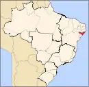 | |
| Palmeira dos Índios | ||
| Traipu | ||
| Litoral Norte Alagoano | ||
| Maceió | ||
| Mata Alagoana | ||
| Penedo | ||
| São Miguel dos Campos | ||
| Serrana dos Quilombos | ||
| Alagoana do Sertão do São Francisco | ||
| Batalha | ||
| Santana do Ipanema | ||
| Serrana do Sertão Alagoano | ||
This article is issued from Wikipedia. The text is licensed under Creative Commons - Attribution - Sharealike. Additional terms may apply for the media files.