Cultural Center O7 文化中心 | |||||||||||||
|---|---|---|---|---|---|---|---|---|---|---|---|---|---|
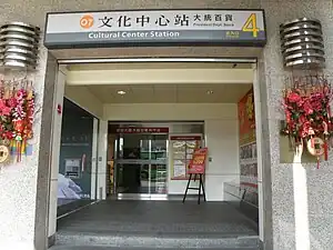 Cultural Center station exit 4 | |||||||||||||
| Chinese name | |||||||||||||
| Traditional Chinese | 文化中心車站 | ||||||||||||
| Simplified Chinese | 文化中心车站 | ||||||||||||
| |||||||||||||
| General information | |||||||||||||
| Location | Sinsing and Lingya, Kaohsiung Taiwan | ||||||||||||
| Operated by | |||||||||||||
| Line(s) |
| ||||||||||||
| Platforms | 1 island platform | ||||||||||||
| Connections | Bus stop | ||||||||||||
| Construction | |||||||||||||
| Structure type | Underground | ||||||||||||
| History | |||||||||||||
| Opened | 2008-09-14 | ||||||||||||
| Passengers | |||||||||||||
| 5,952 daily (Jan. 2011)[1] | |||||||||||||
| Services | |||||||||||||
| |||||||||||||
Cultural Center is a station on the Orange line of Kaohsiung MRT on the edge of Sinsing District and Lingya District, Kaohsiung, Taiwan.
Station overview
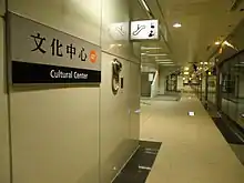
Cultural Center station platform.
The station is a two-level, underground station with an island platform and four exits.[2] The station is 199 metres long and is located at the intersection Jhongjheng 2nd Rd and Heping 1st Rd.[3]
Station layout
| Street Level | Entrance/Exit | Entrance/Exit |
| B1 | Concourse | Lobby, information desk, automatic ticket machines, one-way faregates, Restrooms (Near exits 3) |
| B2 | Platform 1 | ← KMRT Orange Line toward Sizihwan (Sinyi Elementary School) |
| Island platform, doors will open on the left | ||
| Platform 2 | KMRT Orange Line toward Daliao (Wukuaicuo) → | |
Exits
- Exit 1: Jhongjheng 2nd Rd. (west)
- Exit 2: Shangyi St., Wufu Junior High School
- Exit 3: Kaohsiung Cultural Center, National Kaohsiung Normal University
- Exit 4: President Department Store Heping branch, Rainbow Park
Around the station
- Kaohsiung Cultural Center
- National Kaohsiung Normal University
- President Department Store
- Water Tower Park
- Wufu Junior High School
References
Wikimedia Commons has media related to Cultural Center Station.
- ↑ "統計資訊 > 統計月報". Transportation Bureau, Kaohsiung City Government. Retrieved 2011-02-15.
- ↑ "文化中心站". 高雄捷運公司. Archived from the original on 2010-02-25. Retrieved 2010-07-05.
- ↑ "文化中心站週邊地圖". 高雄捷運公司. Archived from the original on 2007-12-04. Retrieved 2010-07-05.
Kaohsiung Metro - Orange line | |
|---|---|
22°37′49″N 120°19′03″E / 22.63028°N 120.31750°E
This article is issued from Wikipedia. The text is licensed under Creative Commons - Attribution - Sharealike. Additional terms may apply for the media files.