| Dadou | |
|---|---|
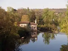 The Dadou at Briatexte | |
.png.webp) | |
| Location | |
| Country | France |
| Physical characteristics | |
| Source | |
| • location | Saint-Salvi-de-Carcavès |
| • coordinates | 43°47′19″N 02°37′32″E / 43.78861°N 2.62556°E |
| • elevation | 860 m (2,820 ft) |
| Mouth | |
• location | Agout |
• coordinates | 43°44′11″N 01°47′24″E / 43.73639°N 1.79000°E |
• elevation | 110 m (360 ft) |
| Length | 115.8 km (72.0 mi) |
| Basin size | 858 km2 (331 sq mi) |
| Discharge | |
| • average | 12 m3/s (420 cu ft/s) |
| Basin features | |
| Progression | Agout→ Tarn→ Garonne→ Gironde estuary→ Atlantic Ocean |
The Dadou (French: le Dadou) is a 115.8 km (72.0 mi) long river in the Tarn department in southern France.[1] Its source is near Saint-Salvi-de-Carcavès. It flows generally west. It is a right tributary of the Agout, into which it flows near Ambres.
Communes along its course
The Dadou flows west, crossing the Tarn department, through the following communes, ordered from source to mouth: Saint-Salvi-de-Carcavès, Le Masnau-Massuguiès, Lacaze, Paulinet, Rayssac, Mont-Roc, Teillet, Le Travet, Arifat, Saint-Antonin-de-Lacalm, Montredon-Labessonnié, Saint-Lieux-Lafenasse, Vénès, Réalmont, Saint-Genest-de-Contest, Lombers, Laboutarie, Montdragon, Saint-Julien-du-Puy, Graulhet, Briatexte, Saint-Gauzens, Puybegon, Giroussens, Ambres
References

Wikimedia Commons has media related to Dadou.
This article is issued from Wikipedia. The text is licensed under Creative Commons - Attribution - Sharealike. Additional terms may apply for the media files.