Darebin | ||||||||||||||||||||||||||||||||||||||||||||||||||||||||
|---|---|---|---|---|---|---|---|---|---|---|---|---|---|---|---|---|---|---|---|---|---|---|---|---|---|---|---|---|---|---|---|---|---|---|---|---|---|---|---|---|---|---|---|---|---|---|---|---|---|---|---|---|---|---|---|---|
| PTV commuter rail station | ||||||||||||||||||||||||||||||||||||||||||||||||||||||||
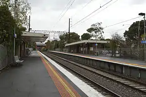 Northbound view from Platform 2 in May 2014 | ||||||||||||||||||||||||||||||||||||||||||||||||||||||||
| General information | ||||||||||||||||||||||||||||||||||||||||||||||||||||||||
| Location | Heidelberg Road, Ivanhoe, Victoria 3079 City of Banyule Australia | |||||||||||||||||||||||||||||||||||||||||||||||||||||||
| Coordinates | 37°46′30″S 145°02′19″E / 37.7750°S 145.0385°E | |||||||||||||||||||||||||||||||||||||||||||||||||||||||
| Owned by | VicTrack | |||||||||||||||||||||||||||||||||||||||||||||||||||||||
| Operated by | Metro Trains | |||||||||||||||||||||||||||||||||||||||||||||||||||||||
| Line(s) | Hurstbridge | |||||||||||||||||||||||||||||||||||||||||||||||||||||||
| Distance | 11.22 kilometres from Southern Cross | |||||||||||||||||||||||||||||||||||||||||||||||||||||||
| Platforms | 2 side | |||||||||||||||||||||||||||||||||||||||||||||||||||||||
| Tracks | 2 | |||||||||||||||||||||||||||||||||||||||||||||||||||||||
| Connections | ||||||||||||||||||||||||||||||||||||||||||||||||||||||||
| Construction | ||||||||||||||||||||||||||||||||||||||||||||||||||||||||
| Structure type | Ground | |||||||||||||||||||||||||||||||||||||||||||||||||||||||
| Parking | 26 | |||||||||||||||||||||||||||||||||||||||||||||||||||||||
| Bicycle facilities | 11 | |||||||||||||||||||||||||||||||||||||||||||||||||||||||
| Accessible | Yes—step free access | |||||||||||||||||||||||||||||||||||||||||||||||||||||||
| Other information | ||||||||||||||||||||||||||||||||||||||||||||||||||||||||
| Status | Operational, unstaffed | |||||||||||||||||||||||||||||||||||||||||||||||||||||||
| Station code | DBN | |||||||||||||||||||||||||||||||||||||||||||||||||||||||
| Fare zone | Myki Zone 1 | |||||||||||||||||||||||||||||||||||||||||||||||||||||||
| Website | Public Transport Victoria | |||||||||||||||||||||||||||||||||||||||||||||||||||||||
| History | ||||||||||||||||||||||||||||||||||||||||||||||||||||||||
| Opened | 8 May 1922 | |||||||||||||||||||||||||||||||||||||||||||||||||||||||
| Rebuilt | 1977/1978 FY | |||||||||||||||||||||||||||||||||||||||||||||||||||||||
| Electrified | July 1921 (1500 V DC overhead) | |||||||||||||||||||||||||||||||||||||||||||||||||||||||
| Passengers | ||||||||||||||||||||||||||||||||||||||||||||||||||||||||
| 2005–2006 | 140,380[1] | |||||||||||||||||||||||||||||||||||||||||||||||||||||||
| 2006–2007 | 149,868[1] | |||||||||||||||||||||||||||||||||||||||||||||||||||||||
| 2007–2008 | 156,480[1] | |||||||||||||||||||||||||||||||||||||||||||||||||||||||
| 2008–2009 | 152,814[2] | |||||||||||||||||||||||||||||||||||||||||||||||||||||||
| 2009–2010 | 158,054[2] | |||||||||||||||||||||||||||||||||||||||||||||||||||||||
| 2010–2011 | 164,624[2] | |||||||||||||||||||||||||||||||||||||||||||||||||||||||
| 2011–2012 | 156,567[2] | |||||||||||||||||||||||||||||||||||||||||||||||||||||||
| 2012–2013 | Not measured[2] | |||||||||||||||||||||||||||||||||||||||||||||||||||||||
| 2013–2014 | 138,344[2] | |||||||||||||||||||||||||||||||||||||||||||||||||||||||
| 2014–2015 | 137,373[1] | |||||||||||||||||||||||||||||||||||||||||||||||||||||||
| 2015–2016 | 151,011[2] | |||||||||||||||||||||||||||||||||||||||||||||||||||||||
| 2016–2017 | 145,776[2] | |||||||||||||||||||||||||||||||||||||||||||||||||||||||
| 2017–2018 | 129,853[2] | |||||||||||||||||||||||||||||||||||||||||||||||||||||||
| 2018–2019 | 150,400[2] | |||||||||||||||||||||||||||||||||||||||||||||||||||||||
| 2019–2020 | 118,850[2] | |||||||||||||||||||||||||||||||||||||||||||||||||||||||
| 2020–2021 | 53,850[2] | |||||||||||||||||||||||||||||||||||||||||||||||||||||||
| 2021–2022 | 60,500[3] | |||||||||||||||||||||||||||||||||||||||||||||||||||||||
| Services | ||||||||||||||||||||||||||||||||||||||||||||||||||||||||
| ||||||||||||||||||||||||||||||||||||||||||||||||||||||||
| ||||||||||||||||||||||||||||||||||||||||||||||||||||||||
Darebin railway station is located on the Hurstbridge line in Victoria, Australia. It serves the north-eastern Melbourne suburb of Ivanhoe, and opened on 8 May 1922.[4][5]
Darebin is the eighth least-used station on Melbourne's electrified rail network.[6]
History
Darebin station opened on 8 May 1922, and is named after the nearby Darebin Creek and the locality of Darebin, which is located west of Ivanhoe.[7] The word is believed to be Indigenous for 'swallow'.[7][8]
In 1951, the line between Alphington and Ivanhoe was duplicated.[4] The present day Platform 2 was also provided in that year.[4]
During the 1977/1978 financial year, the present station buildings were provided.[9]
Platforms and services
Darebin has two side platforms. It is served by Hurstbridge line trains.[10]
Platform 1:
- Hurstbridge line all stations and limited express services to Flinders Street
Platform 2:
- Hurstbridge line all stations and limited express services to Macleod, Greensborough, Eltham and Hurstbridge
Transport links
Dysons operates one bus route via Darebin station, under contract to Public Transport Victoria:
- 546 : Heidelberg station – University of Melbourne (off-peak extension to Queen Victoria Market)[11]
References
- 1 2 3 4 Estimated Annual Patronage by Network Segment Financial Year 2005-2006 to 2018-19 Department of Transport
- 1 2 3 4 5 6 7 8 9 10 11 12 Railway station and tram stop patronage in Victoria for 2008-2021 Philip Mallis
- ↑ Annual metropolitan train station patronage (station entries) Data Vic
- 1 2 3 "Darebin". vicsig.net. Retrieved 28 January 2023.
- ↑ "Darebin Station Opened". The Age. 8 May 1922. Retrieved 9 May 2022.
- ↑ Mallis, Philip. "Which were the least and most used stations in Victoria before COVID?". Victorian Department of Transport. Retrieved 27 June 2022.
- 1 2 "Darebin and Darebin City". Victorian Places. Retrieved 28 January 2023.
- ↑ First, Jamie (7 January 2014). "The A-Z story of Melbourne's suburbs". Herald Sun. Retrieved 28 January 2023.
- ↑ "VicRail Board Report 1977-78". Newsrail. Australian Railway Historical Society. April 1979. p. 52.
- ↑ "Hurstbridge Line". Public Transport Victoria.
- ↑ "546 Heidelberg Station - Melb Uni - Queen Victoria Market via Clifton Hill and Carlton". Public Transport Victoria. Retrieved 15 May 2023.
External links
- Melway map at street-directory.com.au