Demopolis Historic Business District | |
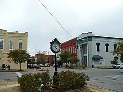 View toward the east down Washington Street | |
  | |
| Location | Demopolis, Alabama, United States |
|---|---|
| Coordinates | 32°31′2″N 87°50′17″W / 32.51722°N 87.83806°W |
| Built | 1850-1949 |
| NRHP reference No. | 79000391[1] |
| Added to NRHP | 25 November 1979[1] |
The Demopolis Historic Business District, currently officially known as Demopolis Historic District, is a historic district in the city of Demopolis, Alabama, United States. Demopolis had its beginnings in 1817 with the Vine and Olive Colony.[2] The historic district is a ten block area, roughly bounded by Capitol Street, Franklin Street, Desnouettes Street, and Cedar Avenue.[1]
The district boundaries were increased, and name was changed to the actual one in October 2014.[3]
References
Wikimedia Commons has media related to Demopolis Historic Business District.
- 1 2 3 "Alabama: Marengo County". "National Register of Historic Places". Retrieved January 23, 2007.
- ↑ Marengo County Heritage Book Committee: The heritage of Marengo County, Alabama, page 4. Clanton, Alabama: Heritage Publishing Consultants, 2000. ISBN 1-891647-58-X
- ↑ "Demopolis Historic District (Boundary Increase)". "National Register of Historic Places". Retrieved April 7, 2017.
| Topics | |
|---|---|
| Lists by state |
|
| Lists by insular areas | |
| Lists by associated state | |
| Other areas | |
| Related | |
This article is issued from Wikipedia. The text is licensed under Creative Commons - Attribution - Sharealike. Additional terms may apply for the media files.