Dierhagen | |
|---|---|
 Protestant church | |
Location of Dierhagen within Vorpommern-Rügen district 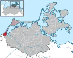 | |
 Dierhagen  Dierhagen | |
| Coordinates: 54°17′29″N 12°21′38″E / 54.29139°N 12.36056°E | |
| Country | Germany |
| State | Mecklenburg-Vorpommern |
| District | Vorpommern-Rügen |
| Municipal assoc. | Darß/Fischland |
| Government | |
| • Mayor | Christiane Müller (Left) |
| Area | |
| • Total | 27.47 km2 (10.61 sq mi) |
| Elevation | 3 m (10 ft) |
| Population (2021-12-31)[1] | |
| • Total | 1,587 |
| • Density | 58/km2 (150/sq mi) |
| Time zone | UTC+01:00 (CET) |
| • Summer (DST) | UTC+02:00 (CEST) |
| Postal codes | 18347 |
| Dialling codes | 038226 |
| Vehicle registration | NVP |
| Website | www |
Dierhagen is a municipality in the Vorpommern-Rügen district, in Mecklenburg-Vorpommern, Germany.
Location
Dierhagen is on the Fischland-Darß-Zingst peninsula. The district is surrounded by the Baltic Sea to the north and northwest and the Saaler Bodden to the east and southeast.[2]
Dierhagen has six districts:
- Dierhagen Dorf
- Dierhagen Strand, a 7-km-long beach with fine white sand
- Dierhagen Ost
- Neuhaus
- Dändorf
- Körkwitz
History
Dierhagen was founded in 1311 when German settlers expanded their territory into the area of Ribnitz (moved eastward).[3]
Notable residents
- Egon Krenz, who briefly served as the leader of East Germany in 1989, has lived in the town since 2003.
References
- ↑ "Bevölkerungsstand der Kreise, Ämter und Gemeinden 2021" (XLS) (in German). Statistisches Amt Mecklenburg-Vorpommern. 2022.
- ↑ "Dierhagen - Ostseebad Dierhagen".
- ↑ "Home". dierhagen1311.de.
External links
 Media related to Dierhagen at Wikimedia Commons
- Dierhagen website, accessed 20. December 2017
This article is issued from Wikipedia. The text is licensed under Creative Commons - Attribution - Sharealike. Additional terms may apply for the media files.