Dlažkovice | |
|---|---|
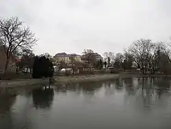 View towards the Dlažkovice Castle | |
 Flag  Coat of arms | |
 Dlažkovice Location in the Czech Republic | |
| Coordinates: 50°27′56″N 13°57′54″E / 50.46556°N 13.96500°E | |
| Country | |
| Region | Ústí nad Labem |
| District | Litoměřice |
| First mentioned | 1057 |
| Area | |
| • Total | 2.69 km2 (1.04 sq mi) |
| Elevation | 275 m (902 ft) |
| Population (2023-01-01)[1] | |
| • Total | 130 |
| • Density | 48/km2 (130/sq mi) |
| Time zone | UTC+1 (CET) |
| • Summer (DST) | UTC+2 (CEST) |
| Postal code | 411 15 |
| Website | www |
Dlažkovice is a municipality and village in Litoměřice District in the Ústí nad Labem Region of the Czech Republic. It has about 100 inhabitants.
Dlažkovice lies approximately 14 kilometres (9 mi) south-west of Litoměřice, 23 km (14 mi) south of Ústí nad Labem, and 53 km (33 mi) north-west of Prague.
References
Wikimedia Commons has media related to Dlažkovice.
This article is issued from Wikipedia. The text is licensed under Creative Commons - Attribution - Sharealike. Additional terms may apply for the media files.