Drahoňův Újezd | |
|---|---|
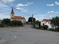 Church of Saint James the Great | |
 Flag  Coat of arms | |
 Drahoňův Újezd Location in the Czech Republic | |
| Coordinates: 49°52′38″N 13°43′33″E / 49.87722°N 13.72583°E | |
| Country | |
| Region | Plzeň |
| District | Rokycany |
| First mentioned | 1352 |
| Area | |
| • Total | 13.99 km2 (5.40 sq mi) |
| Elevation | 410 m (1,350 ft) |
| Population (2023-01-01)[1] | |
| • Total | 124 |
| • Density | 8.9/km2 (23/sq mi) |
| Time zone | UTC+1 (CET) |
| • Summer (DST) | UTC+2 (CEST) |
| Postal code | 338 08 |
| Website | www |
Drahoňův Újezd is a municipality and village in Rokycany District in the Plzeň Region of the Czech Republic. It has about 100 inhabitants.
Drahoňův Újezd lies approximately 16 kilometres (10 mi) north-east of Rokycany, 28 km (17 mi) north-east of Plzeň, and 57 km (35 mi) south-west of Prague.
References
Wikimedia Commons has media related to Drahoňův Újezd.
This article is issued from Wikipedia. The text is licensed under Creative Commons - Attribution - Sharealike. Additional terms may apply for the media files.