Dubodiel | |
|---|---|
Municipality | |
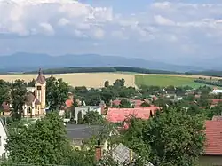 | |
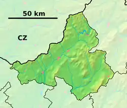 Dubodiel Location of Dubodiel in the Trenčín Region 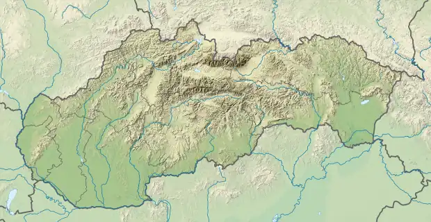 Dubodiel Location of Dubodiel in Slovakia | |
| Coordinates: 48°46′N 18°06′E / 48.767°N 18.100°E | |
| Country | |
| Region | Trenčín |
| District | Trenčín |
| First mentioned | 1439 |
| Area | |
| • Total | 20.191 km2 (7.796 sq mi) |
| Elevation | 390 m (1,280 ft) |
| Population | |
| • Total | 960 |
| • Density | 48/km2 (120/sq mi) |
| Time zone | UTC+1 (CET) |
| • Summer (DST) | UTC+2 (CEST) |
| Postal code | 913 23 |
| Area code | 421-32 |
| Car plate | TN |
| Website | www |
Dubodiel (Hungarian: Trencséntölgyes) is a village and municipality in Trenčín District in the Trenčín Region of north-western Slovakia.
Names and etymology
The name comes from Slovak dub (oak) and diel (a part). Dubodiel - probably an oak forest dividing the landscape into more parts. Dubowy del 1439, Dwbodyel 1493, Dubodiel 1598, Dubodiel 1773.[1]
History
In historical records the village was first mentioned in 1439.
Geography
The municipality lies at an altitude of 310 metres and covers an area of 20.191 km². It has a population of about 960 people.
Genealogical resources
The records for genealogical research are available at the state archive "Statny Archiv in Banska Bystrica, Nitra, Slovakia"
- Roman Catholic church records (births/marriages/deaths): 1782-1896 (parish A)
- Lutheran church records (births/marriages/deaths): 1729-1895 (parish B)
See also
References
- ↑ Krajčovič, Rudolf (2008). "Z lexiky stredovekej slovenčiny s výkladmi názvov obcí a miest (10)". Kultúra slova (in Slovak). Martin: Vydavateľstvo Matice slovenskej (4): 227.
External links
 Media related to Dubodiel at Wikimedia Commons
- Official website

- https://web.archive.org/web/20071027094149/http://www.statistics.sk/mosmis/eng/run.html
- Surnames of living people in Dubodiel
This article is issued from Wikipedia. The text is licensed under Creative Commons - Attribution - Sharealike. Additional terms may apply for the media files.