Edgewater Park, Oklahoma | |
|---|---|
 Edgewater Park  Edgewater Park | |
| Coordinates: 34°49′29″N 98°22′30″W / 34.82472°N 98.37500°W | |
| Country | United States |
| State | Oklahoma |
| County | Comanche |
| Area | |
| • Total | 0.32 sq mi (0.82 km2) |
| • Land | 0.32 sq mi (0.82 km2) |
| • Water | 0.00 sq mi (0.00 km2) |
| Elevation | 1,266 ft (386 m) |
| Population (2020) | |
| • Total | 262 |
| • Density | 823.90/sq mi (317.80/km2) |
| Time zone | UTC-6 (Central (CST)) |
| • Summer (DST) | UTC-5 (CDT) |
| ZIP Code | 73006 (Apache) |
| Area code | 580 |
| FIPS code | 40-23100 |
| GNIS feature ID | 2812847[2] |
Edgewater Park is a census-designated place (CDP) in Comanche County, Oklahoma, United States. It was first listed as a CDP prior to the 2020 census.[2]
The CDP is in northern Comanche County, on high ground overlooking Lake Ellsworth from the west. It is less than 1 mile (1.6 km) east of U.S. Routes 62/281 at a point 16 miles (26 km) north of Lawton and 5 miles (8 km) south of Apache.
Lake Ellsworth is an impoundment on East Cache Creek, a south-flowing tributary of the Red River.
Demographics
| Census | Pop. | Note | %± |
|---|---|---|---|
| 2020 | 262 | — | |
| U.S. Decennial Census[3] | |||
References
- ↑ "ArcGIS REST Services Directory". United States Census Bureau. Retrieved September 20, 2022.
- 1 2 3 U.S. Geological Survey Geographic Names Information System: Edgewater Park, Oklahoma
- ↑ "Census of Population and Housing". Census.gov. Retrieved June 4, 2016.
Municipalities and communities of Comanche County, Oklahoma, United States | ||
|---|---|---|
| Cities | 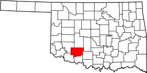 Comanche County map | |
| Towns | ||
| CDPs | ||
| Other communities | ||
| Footnotes | ‡This populated place also has portions in an adjacent county or counties | |
This article is issued from Wikipedia. The text is licensed under Creative Commons - Attribution - Sharealike. Additional terms may apply for the media files.