| Scottish Gaelic name | Eilean Mòr |
|---|---|
| Meaning of name | big island |
| Location | |
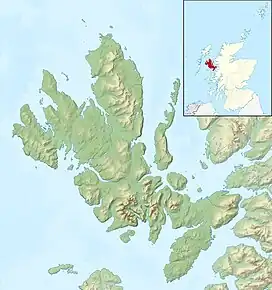 Eilean Mòr Eilean Mòr shown relative to Skye | |
| OS grid reference | NG226487 |
| Coordinates | 57°26′38″N 6°37′26″W / 57.444°N 6.624°W |
| Physical geography | |
| Island group | Skye |
| Area | 17 hectares (42 acres)[1] |
| Highest elevation | 23 metres (75 ft) |
| Administration | |
| Sovereign state | United Kingdom |
| Country | Scotland |
| Council area | Highland |
| Demographics | |
| Population | 0 |
| References | [2] |
Eilean Mòr is an uninhabited island in Loch Dunvegan in north west Skye, Scotland. At low water the island is connected to Eilean Dubh.[3]
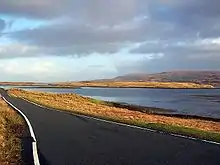
Eilean Mòr beyond Loch Erghallan
Footnotes
- ↑ Rick Livingstone’s Tables of the Islands of Scotland (pdf) Argyll Yacht Charters. Retrieved 12 Dec 2011.
- ↑ Ordnance Survey. OS Maps Online (Map). 1:25,000. Leisure.
- ↑ "Eilean Mòr". Gazetteer for Scotland. Retrieved 13 December 2009.
Wikimedia Commons has media related to Eilean Mòr.
57°26′39″N 6°37′28″W / 57.44417°N 6.62444°W
This article is issued from Wikipedia. The text is licensed under Creative Commons - Attribution - Sharealike. Additional terms may apply for the media files.