Elrod, Alabama | |
|---|---|
 Elrod, Alabama  Elrod, Alabama | |
| Coordinates: 33°15′22″N 87°47′32″W / 33.25611°N 87.79222°W | |
| Country | United States |
| State | Alabama |
| County | Tuscaloosa |
| Elevation | 246 ft (75 m) |
| Time zone | UTC-6 (Central (CST)) |
| • Summer (DST) | UTC-5 (CDT) |
| ZIP code | 35458 |
| Area code(s) | 205, 659 |
| GNIS feature ID | 117963[1] |
Elrod is an unincorporated community in Tuscaloosa County, Alabama, United States. Elrod is located on County Route 15, 13.3 miles (21.4 km) west-northwest of Tuscaloosa.[2] Elrod has a post office with ZIP code 35458.[3] Elrod was renamed from Sipsey Turnpike in 1898 after the Mobile and Ohio Railroad reached the community. It was named in honor of William W. Elrod, a local physician.[4]
Climate
The climate in this area is characterized by hot, humid summers and generally mild to cool winters. According to the Köppen Climate Classification system, Elrod has a humid subtropical climate, abbreviated "Cfa" on climate maps.[5]
References
- ↑ "Elrod". Geographic Names Information System. United States Geological Survey, United States Department of the Interior.
- ↑ Tuscaloosa County, Alabama General Highway Map (PDF) (Map). Alabama Department of Transportation. 2008. Retrieved March 11, 2012.
- ↑ United States Postal Service (2012). "USPS - Look Up a ZIP Code". Retrieved February 15, 2012.
- ↑ Foscue, Virginia (1989). Place Names in Alabama. Tuscaloosa: The University of Alabama Press. p. 52. ISBN 0-8173-0410-X.
- ↑ Climate Summary for Elrod, Alabama
Municipalities and communities of Tuscaloosa County, Alabama, United States | ||
|---|---|---|
| Cities | 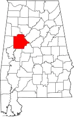 Map of Alabama highlighting Tuscaloosa County | |
| Towns | ||
| CDPs | ||
| Other unincorporated communities | ||
| Ghost town | ||
| Footnotes | ‡This populated place also has portions in an adjacent county or counties | |
This article is issued from Wikipedia. The text is licensed under Creative Commons - Attribution - Sharealike. Additional terms may apply for the media files.