Enemy Swim, South Dakota | |
|---|---|
 Enemy Swim  Enemy Swim | |
| Coordinates: 45°25′55″N 97°17′12″W / 45.43194°N 97.28667°W | |
| Country | United States |
| State | South Dakota |
| County | Day |
| Area | |
| • Total | 1.51 sq mi (3.91 km2) |
| • Land | 0.93 sq mi (2.42 km2) |
| • Water | 0.57 sq mi (1.49 km2) |
| Elevation | 1,870 ft (570 m) |
| Population | |
| • Total | 310 |
| • Density | 331.91/sq mi (128.10/km2) |
| Time zone | UTC-6 (Central (CST)) |
| • Summer (DST) | UTC-5 (CDT) |
| ZIP Code | 57273 (Waubay) |
| Area code | 605 |
| FIPS code | 46-19556 |
| GNIS feature ID | 2807099[2] |
Enemy Swim is an unincorporated community and census-designated place (CDP) on the Lake Traverse Indian Reservation in Day County, South Dakota, United States. The population was 310 at the 2020 census.[4] It was first listed as a CDP prior to the 2020 census.[2]
It is in the eastern part of the county, surrounding the west cove of Enemy Swim Lake and extending south to include the northwest shore of Campbell Slough. It is 8 miles (13 km) north of Waubay and 19 miles (31 km) by road northeast of Webster, the county seat.
Demographics
| Census | Pop. | Note | %± |
|---|---|---|---|
| 2020 | 310 | — | |
| U.S. Decennial Census[5] | |||
References
- ↑ "ArcGIS REST Services Directory". United States Census Bureau. Retrieved October 15, 2022.
- 1 2 3 U.S. Geological Survey Geographic Names Information System: Enemy Swim, South Dakota
- ↑ "Census Population API". United States Census Bureau. Retrieved October 15, 2022.
- ↑ "U.S. Census Bureau: Enemy Swim CDP, South Dakota". www.census.gov. United States Census Bureau. Retrieved March 22, 2022.
- ↑ "Census of Population and Housing". Census.gov. Retrieved June 4, 2016.
Municipalities and communities of Day County, South Dakota, United States | ||
|---|---|---|
| Cities | 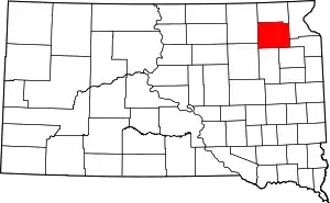 | |
| Towns | ||
| CDP | ||
| Other communities | ||
| Indian reservation | ||
| Footnotes | ‡This populated place also has portions in an adjacent county or counties | |
This article is issued from Wikipedia. The text is licensed under Creative Commons - Attribution - Sharealike. Additional terms may apply for the media files.