Farafangana | |
|---|---|
City | |
 View to a landscape near the city. | |
 Location of Farafangana in Madagascar | |
| Country | Madagascar |
| Region | Atsimo-Atsinanana |
| District | Farafangana (district) |
| Area | |
| • Total | 27.0 km2 (10.4 sq mi) |
| Elevation | 15 m (49 ft) |
| Population (2018 census) | |
| • Total | 34,676 |
| • Density | 1,300/km2 (3,300/sq mi) |
| Time zone | UTC+3 (EAT) |
| postal code | 309 |
| Climate | Af |
| Website | www |
Farafangana is a city (commune urbaine) on the south-east coast of Madagascar and capital of the Atsimo-Atsinanana region.
Location
Farafangana is the capital of the region Atsimo-Atsinanana located approximately 400 kilometres south of the capital Antananarivo. It is at the southern end of the Canal des Pangalanes,[1] with the mouth of the Manampatrana River located on the north side of the town. It is 106km south of Manakara, about 2.5 hours travel time away.[2]
Settlements located to the north include Lokandambo, Manambotra, Ambahikarabo and Amboahangimamy, with Ambalolo to the west. To the south are Antananabo, Manambotra Atsimo and Marosondry.[3]
Economy
There is an airport in Farafangana (Farafangana Airport). One of the main crops in the region is pepper.[4]
Population
Natives are mainly from ethnic groups Antefasy, Rabakara, Antesaka and Zafisoro.
Education
Farafangana has a university.[5]
Tourism
The Manombo Reserve is located at 25 km to Farafangana.[6]
Roads
- National Road RN 12 from Irondro/Mananjary to Vangaindrano in the South.
- National Road RN 27 to Ihosy.
Rivers
The Manambava and the Manampatrana River that has its mouth into the Indian Ocean at Farafangana.
Sports
- Dato Farafangana FC is the local football club.
Climate
| Climate data for Farafangana (1991–2020) | |||||||||||||
|---|---|---|---|---|---|---|---|---|---|---|---|---|---|
| Month | Jan | Feb | Mar | Apr | May | Jun | Jul | Aug | Sep | Oct | Nov | Dec | Year |
| Record high °C (°F) | 34.5 (94.1) |
34.4 (93.9) |
34.8 (94.6) |
34.5 (94.1) |
33.7 (92.7) |
31.5 (88.7) |
30.7 (87.3) |
29.9 (85.8) |
30.8 (87.4) |
32.1 (89.8) |
33.3 (91.9) |
34.1 (93.4) |
34.8 (94.6) |
| Mean daily maximum °C (°F) | 29.5 (85.1) |
29.7 (85.5) |
29.4 (84.9) |
28.5 (83.3) |
27.1 (80.8) |
25.1 (77.2) |
24.2 (75.6) |
24.3 (75.7) |
25.4 (77.7) |
26.8 (80.2) |
28.2 (82.8) |
29.4 (84.9) |
27.3 (81.1) |
| Daily mean °C (°F) | 26.6 (79.9) |
26.7 (80.1) |
26.3 (79.3) |
25.2 (77.4) |
23.4 (74.1) |
21.4 (70.5) |
20.6 (69.1) |
20.9 (69.6) |
22.1 (71.8) |
23.7 (74.7) |
25.1 (77.2) |
26.3 (79.3) |
24.0 (75.2) |
| Mean daily minimum °C (°F) | 23.7 (74.7) |
23.7 (74.7) |
23.2 (73.8) |
21.9 (71.4) |
19.7 (67.5) |
17.7 (63.9) |
16.9 (62.4) |
17.4 (63.3) |
18.7 (65.7) |
20.5 (68.9) |
22.0 (71.6) |
23.1 (73.6) |
20.7 (69.3) |
| Record low °C (°F) | 17.1 (62.8) |
17.8 (64.0) |
17.0 (62.6) |
13.5 (56.3) |
12.1 (53.8) |
11.2 (52.2) |
11.2 (52.2) |
11.5 (52.7) |
12.3 (54.1) |
14.2 (57.6) |
14.9 (58.8) |
17.0 (62.6) |
11.2 (52.2) |
| Average precipitation mm (inches) | 269.5 (10.61) |
254.8 (10.03) |
294.3 (11.59) |
229.6 (9.04) |
208.7 (8.22) |
138.6 (5.46) |
148.8 (5.86) |
73.3 (2.89) |
69.6 (2.74) |
82.5 (3.25) |
87.2 (3.43) |
159.3 (6.27) |
2,016.2 (79.38) |
| Average precipitation days (≥ 1.0 mm) | 17.6 | 16.7 | 17.7 | 15.2 | 14.0 | 12.9 | 13.2 | 10.0 | 8.3 | 8.1 | 9.2 | 12.5 | 155.4 |
| Source: NOAA[7] | |||||||||||||
See also
References
- ↑ Madagascar & Comoros, p. 232 (Lonely Planet, 2008)
- ↑ Madagascar 2014-2015 Petit Futé, p. 249 (2013)
- ↑ "Redirect to /World/MA/02/Farafangana.HTML".
- ↑ (in French) www.commerce.gov.mg Archived 2013-03-24 at the Wayback Machine
- ↑ centre universitaire à Farafangana
- ↑ "travalmadagascar.org". Archived from the original on 2020-03-27. Retrieved 2013-03-25.
- ↑ "Farafangana Climate Normals 1991–2020". World Meteorological Organization Climatological Standard Normals (1991–2020). National Oceanic and Atmospheric Administration. Archived from the original on 25 September 2023. Retrieved 25 September 2023.
22°49′S 47°49′E / 22.817°S 47.817°E
Capital: Farafangana | ||
| Befotaka Sud (6) - 307 | 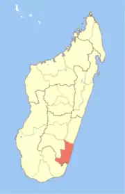 | |
| Farafangana (30) - 309 |
| |
| Midongy-Atsimo (6) - 318 | ||
| Vangaindrano (28) - 320 | ||
| Vondrozo (16) - 322 | ||
5 districts; 86 communes | ||