Faux Cap
Betanty | |
|---|---|
 Faux Cap | |
 Faux Cap Location in Madagascar | |
| Coordinates: 25°34′S 45°31′E / 25.567°S 45.517°E | |
| Country | |
| Region | Androy |
| District | Tsiombe |
| Elevation | 23 m (75 ft) |
| Population (2001)[2] | |
| • Total | 16,000 |
| Time zone | UTC3 (EAT) |
Faux Cap or Betanty is a municipality in Madagascar. It belongs to the district of Tsiombe, which is a part of the Androy Region. The population of the commune was estimated to be approximately 16,000 in the 2001 commune census.[2]
Primary and junior level secondary education are available in the town. Farming and raising livestock provides employment for 36% of the working population. The most important crops are sweet potatoes and cowpeas, while other important agricultural products are maize and cassava. Services provide employment for 2% of the population. Additionally fishing employs 26% of the population.[2]
Geography
Faux Cap is situated in the extreme South of Madagascar, about 30 km South of Tsihombe.
References
- ↑ Estimated based on DEM data from Shuttle Radar Topography Mission
- 1 2 3 "ILO census data". Cornell University. 2002. Retrieved 2008-05-02.
Capital: Ambovombe-Androy | ||
| Ambovombe (21) (604) | 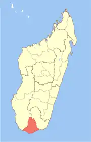 | |
| Bekily (20) (607) |
| |
| Beloha (8) (609) | ||
| Tsiombe (7) (621) |
| |
| proposed Antanimora Sud (9) (604) |
| |
4 districts; 56 communes | ||
25°34′S 45°31′E / 25.567°S 45.517°E
Wikimedia Commons has media related to Faux Cap.
This article is issued from Wikipedia. The text is licensed under Creative Commons - Attribution - Sharealike. Additional terms may apply for the media files.