State Road 674 | ||||
|---|---|---|---|---|
| Route information | ||||
| Maintained by FDOT | ||||
| Length | 25.509 mi[1] (41.053 km) | |||
| Major junctions | ||||
| West end |  US 41 in Ruskin US 41 in Ruskin | |||
| ||||
| East end |  SR 37 south of Bradley Junction SR 37 south of Bradley Junction | |||
| Location | ||||
| Country | United States | |||
| State | Florida | |||
| Counties | Hillsborough, Polk | |||
| Highway system | ||||
| ||||


Florida State Road 674 (SR 674) begins in Ruskin, Hillsborough County, Florida. The road runs east/west and is also known as College Avenue and Sun City Center Boulevard.
Route description
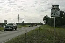
Sign for State Road 674, located in Fort Lonesome
Major intersections
| County | Location | mi[1] | km | Destinations | Notes |
|---|---|---|---|---|---|
| Hillsborough | Ruskin | 0.000 | 0.000 | US 41 (SR 45) – Port Manatee | |
| | 3.02 | 4.86 |  I-75 (SR 93A) – Tampa, Naples I-75 (SR 93A) – Tampa, Naples | I-75 exit 240 | |
| | 6.070 | 9.769 |  US 301 (SR 43) – Riverview, Parrish, Little Manatee River State Park US 301 (SR 43) – Riverview, Parrish, Little Manatee River State Park | ||
| Wimauma | 8.475 | 13.639 |   CR 579 south CR 579 south | ||
| Fort Lonesome | 17.792 | 28.633 |  CR 39 – Alafia River State Park CR 39 – Alafia River State Park | ||
| Polk | | 25.509 | 41.053 | SR 37 – Mulberry, Lakeland | |
| 1.000 mi = 1.609 km; 1.000 km = 0.621 mi | |||||
References
- 1 2 FDOT straight line diagrams Archived March 6, 2014, at the Wayback Machine, accessed March 2014
External links
Template:Attached KML/Florida State Road 674
KML is not from Wikidata
 Media related to Florida State Road 674 at Wikimedia Commons
- Florida Route Log (SR 674)
This article is issued from Wikipedia. The text is licensed under Creative Commons - Attribution - Sharealike. Additional terms may apply for the media files.