Fompedraza | |
|---|---|
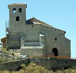 San Bartolomé Church, built in the 12th century. | |
.svg.png.webp) Flag .svg.png.webp) Coat of arms | |
 Fompedraza Location in Spain. | |
| Coordinates: 41°32′10″N 4°8′45″W / 41.53611°N 4.14583°W | |
| Country | Spain |
| Autonomous community | Castile and León |
| Province | Valladolid |
| Comarca | Campo de Peñafiel |
| Government | |
| • Mayor | María Amparo Arranz Sanz |
| Area | |
| • Total | 16.38 km2 (6.32 sq mi) |
| Elevation | 889 m (2,917 ft) |
| Population (2018)[1] | |
| • Total | 110 |
| • Density | 6.7/km2 (17/sq mi) |
| Demonym | Patajas |
| Time zone | UTC+1 (CET) |
| • Summer (DST) | UTC+2 (CEST) |
| Postal code | 47311 |
Fompedraza is a municipality located in the province of Valladolid, Castile and León, Spain. As of 2010(INE), the municipality has a population of 138 inhabitants.
References
- ↑ Municipal Register of Spain 2018. National Statistics Institute.

This article is issued from Wikipedia. The text is licensed under Creative Commons - Attribution - Sharealike. Additional terms may apply for the media files.