Fostoria, Kansas | |
|---|---|
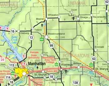 KDOT map of Pottawatomie County (legend) | |
 Fostoria  Fostoria | |
| Coordinates: 39°26′23″N 96°30′28″W / 39.43972°N 96.50778°W[1] | |
| Country | United States |
| State | Kansas |
| County | Pottawatomie |
| Elevation | 1,473 ft (449 m) |
| Time zone | UTC-6 (CST) |
| • Summer (DST) | UTC-5 (CDT) |
| ZIP code | 66426 |
| Area code | 785 |
| FIPS code | 20-24050 |
| GNIS ID | 476080 [1] |
Fostoria is an unincorporated community in Pottawatomie County, Kansas, United States.[1] Fostoria is 6 miles (9.7 km) east of Olsburg. Fostoria has a post office with ZIP code 66426.[2]
History
The first post office in Fostoria was established in 1884.[3]
Climate
The climate in this area is characterized by hot, humid summers and generally mild to cool winters. According to the Köppen Climate Classification system, Fostoria has a humid subtropical climate, abbreviated "Cfa" on climate maps.[4]
Education
The community is served by Blue Valley USD 384 public school district.
References
- 1 2 3 4 "Fostoria, Kansas", Geographic Names Information System, United States Geological Survey, United States Department of the Interior
- ↑ "ZIP Code Lookup". Archived from the original on June 15, 2011. Retrieved November 2, 2009.
- ↑ "Kansas Post Offices, 1828-1961". Kansas Historical Society. Archived from the original on October 9, 2013. Retrieved June 22, 2014.
- ↑ Climate Summary for Fostoria, Kansas
Further reading
External links
Municipalities and communities of Pottawatomie County, Kansas, United States | ||
|---|---|---|
| Cities | 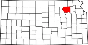 Map of Kansas highlighting Pottawatomie County | |
| Unincorporated communities | ||
| Footnotes | ‡This community also has portions in an adjacent county or counties. | |
This article is issued from Wikipedia. The text is licensed under Creative Commons - Attribution - Sharealike. Additional terms may apply for the media files.