Francheville | |
|---|---|
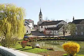 The lake and church in the centre of the village | |
.svg.png.webp) Coat of arms | |
Location of Francheville | |
 Francheville  Francheville | |
| Coordinates: 47°27′21″N 4°53′00″E / 47.4558°N 4.8833°E | |
| Country | France |
| Region | Bourgogne-Franche-Comté |
| Department | Côte-d'Or |
| Arrondissement | Dijon |
| Canton | Is-sur-Tille |
| Government | |
| • Mayor (2020–2026) | Gilles Duthu[1] |
| Area 1 | 31.65 km2 (12.22 sq mi) |
| Population | 269 |
| • Density | 8.5/km2 (22/sq mi) |
| Time zone | UTC+01:00 (CET) |
| • Summer (DST) | UTC+02:00 (CEST) |
| INSEE/Postal code | 21284 /21440 |
| Elevation | 344–563 m (1,129–1,847 ft) (avg. 480 m or 1,570 ft) |
| 1 French Land Register data, which excludes lakes, ponds, glaciers > 1 km2 (0.386 sq mi or 247 acres) and river estuaries. | |
Francheville (French pronunciation: [fʁɑ̃ʃvil] ⓘ) is a commune in the Côte-d'Or department in eastern France.
Population
| Year | Pop. | ±% |
|---|---|---|
| 1962 | 99 | — |
| 1968 | 132 | +33.3% |
| 1975 | 138 | +4.5% |
| 1982 | 142 | +2.9% |
| 1990 | 205 | +44.4% |
| 1999 | 199 | −2.9% |
| 2008 | 247 | +24.1% |
See also
References
- ↑ "Répertoire national des élus: les maires" (in French). data.gouv.fr, Plateforme ouverte des données publiques françaises. 13 September 2022.
- ↑ "Populations légales 2021". The National Institute of Statistics and Economic Studies. 28 December 2023.
Wikimedia Commons has media related to Francheville (Côte-d'Or).
This article is issued from Wikipedia. The text is licensed under Creative Commons - Attribution - Sharealike. Additional terms may apply for the media files.