Gurgy-la-Ville | |
|---|---|
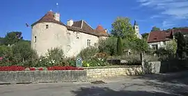 A general view of Gurgy-la-Ville | |
.svg.png.webp) Coat of arms | |
Location of Gurgy-la-Ville | |
 Gurgy-la-Ville  Gurgy-la-Ville | |
| Coordinates: 47°51′01″N 4°56′30″E / 47.8503°N 4.9417°E | |
| Country | France |
| Region | Bourgogne-Franche-Comté |
| Department | Côte-d'Or |
| Arrondissement | Montbard |
| Canton | Châtillon-sur-Seine |
| Intercommunality | Pays Châtillonnais |
| Government | |
| • Mayor (2020–2026) | Katia Sullerot[1] |
| Area 1 | 12.77 km2 (4.93 sq mi) |
| Population | 26 |
| • Density | 2.0/km2 (5.3/sq mi) |
| Time zone | UTC+01:00 (CET) |
| • Summer (DST) | UTC+02:00 (CEST) |
| INSEE/Postal code | 21312 /21290 |
| Elevation | 282–419 m (925–1,375 ft) (avg. 378 m or 1,240 ft) |
| 1 French Land Register data, which excludes lakes, ponds, glaciers > 1 km2 (0.386 sq mi or 247 acres) and river estuaries. | |
Gurgy-la-Ville (French pronunciation: [gyʁʒi la vil]) is a commune in the Côte-d'Or department in eastern France.
Population
| Year | Pop. | ±% |
|---|---|---|
| 1962 | 63 | — |
| 1968 | 77 | +22.2% |
| 1975 | 59 | −23.4% |
| 1982 | 54 | −8.5% |
| 1990 | 45 | −16.7% |
| 1999 | 46 | +2.2% |
| 2008 | 38 | −17.4% |
See also
References
- ↑ "Répertoire national des élus: les maires" (in French). data.gouv.fr, Plateforme ouverte des données publiques françaises. 13 September 2022.
- ↑ "Populations légales 2021". The National Institute of Statistics and Economic Studies. 28 December 2023.
Wikimedia Commons has media related to Gurgy-la-Ville.
This article is issued from Wikipedia. The text is licensed under Creative Commons - Attribution - Sharealike. Additional terms may apply for the media files.