Frankfurter Berg | |
|---|---|
Location of Frankfurter Berg (red) and the Ortsbezirk Nord-Ost (light red) within Frankfurt am Main 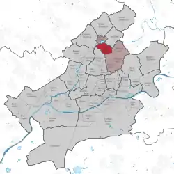 | |
 Frankfurter Berg  Frankfurter Berg | |
| Coordinates: 50°10′21″N 08°40′43″E / 50.17250°N 8.67861°E | |
| Country | Germany |
| State | Hesse |
| Admin. region | Darmstadt |
| District | Urban district |
| City | Frankfurt am Main |
| Area | |
| • Total | 2.185 km2 (0.844 sq mi) |
| Population (2020-12-31)[1] | |
| • Total | 8,225 |
| • Density | 3,800/km2 (9,700/sq mi) |
| Time zone | UTC+01:00 (CET) |
| • Summer (DST) | UTC+02:00 (CEST) |
| Postal codes | 60433 |
| Dialling codes | 069 |
| Vehicle registration | F |
| Website | www.frankfurterberg.de |
Frankfurter Berg is a quarter of Frankfurt am Main, Germany, situated on a hill above the river Nidda.[2] It is part of the Ortsbezirk Nord-Ost.
References
- ↑ "Frankfurt Statsitik Aktuell 07/2021". Stadt Frankfurt am Main. July 2021.
- ↑ "Frankfurter Berg (Quarter, Frankfurt am Main, Germany) - Population Statistics, Charts, Map and Location". www.citypopulation.de. Retrieved 2017-09-11.
This article is issued from Wikipedia. The text is licensed under Creative Commons - Attribution - Sharealike. Additional terms may apply for the media files.