Fridolfing | |
|---|---|
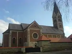 Assumption of the Virgin Mary Church | |
 Coat of arms | |
Location of Fridolfing within Traunstein district 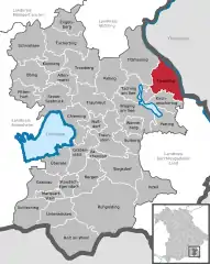 | |
 Fridolfing  Fridolfing | |
| Coordinates: 48°0′N 12°49′E / 48.000°N 12.817°E | |
| Country | Germany |
| State | Bavaria |
| Admin. region | Oberbayern |
| District | Traunstein |
| Government | |
| • Mayor (2020–26) | Johann Schild[1] (SPD) |
| Area | |
| • Total | 44.23 km2 (17.08 sq mi) |
| Elevation | 388 m (1,273 ft) |
| Population (2022-12-31)[2] | |
| • Total | 4,489 |
| • Density | 100/km2 (260/sq mi) |
| Time zone | UTC+01:00 (CET) |
| • Summer (DST) | UTC+02:00 (CEST) |
| Postal codes | 83413 |
| Dialling codes | 08684 |
| Vehicle registration | TS |
| Website | www.fridolfing.de |
Fridolfing is a municipality in the district of Traunstein in Bavaria, Germany.
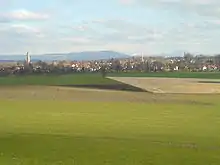
Panorama
References
- ↑ Liste der ersten Bürgermeister/Oberbürgermeister in kreisangehörigen Gemeinden, Bayerisches Landesamt für Statistik, 15 July 2021.
- ↑ Genesis Online-Datenbank des Bayerischen Landesamtes für Statistik Tabelle 12411-003r Fortschreibung des Bevölkerungsstandes: Gemeinden, Stichtag (Einwohnerzahlen auf Grundlage des Zensus 2011)
This article is issued from Wikipedia. The text is licensed under Creative Commons - Attribution - Sharealike. Additional terms may apply for the media files.