Frojach-Katsch | |
|---|---|
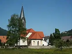 Church in Frojach | |
 Coat of arms | |
 Frojach-Katsch Location within Austria | |
| Coordinates: 47°08′00″N 14°18′00″E / 47.13333°N 14.30000°E | |
| Country | Austria |
| State | Styria |
| District | Murau |
| Government | |
| • Mayor | Wilhelm Schnedl (SPÖ) |
| Area | |
| • Total | 38.89 km2 (15.02 sq mi) |
| Elevation | 762 m (2,500 ft) |
| Population (1 January 2016)[1] | |
| • Total | 1,155 |
| • Density | 30/km2 (77/sq mi) |
| Time zone | UTC+1 (CET) |
| • Summer (DST) | UTC+2 (CEST) |
| Postal code | 8841 (Frojach), 8842 (Katsch) |
| Area code | 03588 |
| Vehicle registration | MU |
| Website | www.frojach-katsch.steiermark.at |
Frojach-Katsch is a former municipality in the district of Murau in Styria, Austria. Since the 2015 Styria municipal structural reform, it is part of the municipality Teufenbach-Katsch.[2]
Population
| Year | Pop. | ±% |
|---|---|---|
| 1869 | 936 | — |
| 1880 | 846 | −9.6% |
| 1890 | 855 | +1.1% |
| 1900 | 846 | −1.1% |
| 1910 | 908 | +7.3% |
| 1923 | 944 | +4.0% |
| 1934 | 1,105 | +17.1% |
| 1939 | 1,154 | +4.4% |
| 1951 | 1,182 | +2.4% |
| 1961 | 1,180 | −0.2% |
| 1971 | 1,187 | +0.6% |
| 1981 | 1,984 | +67.1% |
| 1991 | 1,175 | −40.8% |
| 2001 | 1,248 | +6.2% |
| 2011 | 1,199 | −3.9% |
References
This article is issued from Wikipedia. The text is licensed under Creative Commons - Attribution - Sharealike. Additional terms may apply for the media files.