Gadsden, South Carolina | |
|---|---|
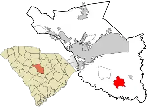
 Location in Richland County and the state of South Carolina. | |
| Coordinates: 33°50′44″N 80°45′57″W / 33.84556°N 80.76583°W | |
| Country | United States |
| State | South Carolina |
| County | Richland |
| Area | |
| • Total | 11.51 sq mi (29.80 km2) |
| • Land | 11.51 sq mi (29.80 km2) |
| • Water | 0.00 sq mi (0.00 km2) |
| Elevation | 154 ft (47 m) |
| Population | |
| • Total | 1,301 |
| • Density | 113.07/sq mi (43.66/km2) |
| Time zone | UTC-5 (Eastern (EST)) |
| • Summer (DST) | UTC-4 (EDT) |
| ZIP code | 29052 |
| FIPS code | 45-27970[4] |
| GNIS feature ID | 1249488[2] |
Gadsden is a census-designated place in Richland County, South Carolina, United States. The population was 1,632 at the 2010 census.[5] It is part of the Columbia, South Carolina metropolitan area.
History
The John J. Kaminer House, Magnolia, Oakwood, and Richland Presbyterian Church are listed on the National Register of Historic Places.[6]
Geography
Gadsden is located at latitude 33.846 North and longitude 80.766 West. The elevation is 148 feet (45 m) above sea level.[7] According to the U.S. Census Bureau, the town has an area of 11.5 square miles (29.8 km2), of which 0.008 square miles (0.02 km2), or 0.06%, is water.[5] The community is located at the intersection of state highways 48 and 769.
Demographics
| Census | Pop. | Note | %± |
|---|---|---|---|
| 2020 | 1,301 | — | |
| U.S. Decennial Census[8] | |||
2020 census
| Race | Num. | Perc. |
|---|---|---|
| White (non-Hispanic) | 83 | 6.38% |
| Black or African American (non-Hispanic) | 1,154 | 88.7% |
| Native American | 2 | 0.15% |
| Asian | 1 | 0.08% |
| Other/Mixed | 37 | 2.84% |
| Hispanic or Latino | 24 | 1.84% |
As of the 2020 United States census, there were 1,301 people, 546 households, and 425 families residing in the Town.
References
- ↑ "ArcGIS REST Services Directory". United States Census Bureau. Retrieved October 15, 2022.
- 1 2 U.S. Geological Survey Geographic Names Information System: Gadsden, South Carolina
- ↑ "Census Population API". United States Census Bureau. Retrieved October 15, 2022.
- ↑ "U.S. Census website". United States Census Bureau. Retrieved January 31, 2008.
- 1 2 "Geographic Identifiers: 2010 Demographic Profile Data (G001): Gadsden CDP, South Carolina". U.S. Census Bureau, American Factfinder. Archived from the original on February 12, 2020. Retrieved January 14, 2013.
- ↑ "National Register Information System". National Register of Historic Places. National Park Service. July 9, 2010.
- ↑ "Gadsden, South Carolina". HomeTownLocator.
- ↑ "Census of Population and Housing". Census.gov. Retrieved June 4, 2016.
- ↑ "Explore Census Data". data.census.gov. Retrieved December 13, 2021.
