Gauriganj
गौरिगञ्ज | |
|---|---|
| Gauriganj Gaunpalika | |
| Country |  Nepal Nepal |
| Province | Province No. 1 |
| District | Jhapa |
| Wards | 6 |
| Government | |
| • Type | Local Government |
| • Chairperson | Fulwati Rajbanshi (NC)[1] |
| • Vice-Chairperson | Pujan Neupane (CON-UML)[1] |
| Area | |
| • Total | 101.35 km2 (39.13 sq mi) |
| Elevation | 80 m (260 ft) |
| Population (2021[2]) | |
| • Total | 36,145 |
| • Density | 360/km2 (920/sq mi) |
| Languages | |
| • Official | Nepali |
| • Local | Rajbanshi, surjapuri, Hindi |
| Time zone | UTC+5:45 (NST) |
| Postal code | 57200 |
| Website | |
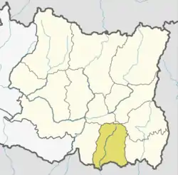
Gauriganj (Nepali: गौरिगञ्ज) is a village and village development committee in the southwest corner of Jhapa District in the Mechi Zone of southeastern Nepal.[3] It is in a flat agricultural district in the extreme southeast of Nepal, between Kadamgachhi, Hukkagachhi and Bhavanipur, only about 3 km from the border with Bihar, India.
References
- 1 2 "गौरिगञ्ज गाउँपालिका गृहपृष्ठ". गौरिगञ्ज गाउँपालिका. Archived from the original on 2021-01-23. Retrieved 2018-10-28.
- ↑ "Preliminary Report of Census 2021" (PDF). cbs.gov.np. Archived from the original (PDF) on 6 February 2022. Retrieved 24 February 2022.
- ↑ "Nepal Census 2001". Nepal's Village Development Committees. Digital Himalaya. Archived from the original on 12 October 2008. Retrieved 24 November 2008.

Wikivoyage has a travel guide for Gauriganj, Nepal.
Places adjacent to Gauriganj, Nepal | |
|---|---|


This article is issued from Wikipedia. The text is licensed under Creative Commons - Attribution - Sharealike. Additional terms may apply for the media files.