Gmina Szydłów
Szydłów Commune | |
|---|---|
 Coat of arms | |
 | |
| Coordinates (Szydłów): 50°36′18.44″N 20°59′01.85″E / 50.6051222°N 20.9838472°E | |
| Country |  Poland Poland |
| Voivodeship | Świętokrzyskie |
| County | Staszów |
| Seat | Szydłów |
| Area (through the years 2006–2010)[1] | |
| • Total | 107.90 km2 (41.66 sq mi) |
| Population (31 December 2010 at Census)[1] | |
| • Total | 4,800 |
| • Density | 44/km2 (120/sq mi) |
| Time zone | UTC+1 (CET) |
| • Summer (DST) | UTC+2 (CEST) |
| Postal code | 28-225 |
| Area code | +48 41 |
| Car plates | TSZ |
| Website | http://www.szydlow.pl |
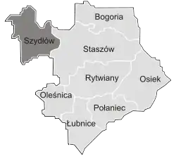
Gmina Szydłów[2] is a rural gmina (administrative district) in Staszów County, Świętokrzyskie Voivodeship, in south-central Poland. Its seat is the village of Szydłów, which lies approximately 13 kilometres (8 mi) west of Staszów and 43 km (27 mi) south-east of the regional capital Kielce.
The gmina covers an area of 107.90 square kilometres (41.7 sq mi), and as of 2010 its total population is  4,800.
Demography
According to the 2011 Poland census, there were 4,800 people residing in Szydłów Commune, of whom 50.7% were male and 49.3% were female. In the commune, the population was spread out, with 18.1% under the age of 18, 36.8% from 18 to 44, 25.6% from 45 to 64, and 19.5% who were 65 years of age or older.[1]
Table 1. Population level of commune in 2010 – by age group[1] SPECIFICATION Measure
unitPOPULATION
(by age group in 2010)TOTAL 0–4 5–9 10–14 15–19 20–24 25–29 30–34 35–39 40–44 45–49 50–54 55–59 60–64 65–69 70–74 75–79 80–84 85 + I. TOTAL person 4,800 234 208 260 296 408 410 286 273 262 366 377 339 292 135 180 192 185 97 — of which in % 100 4.9 4.3 5.4 6.2 8.5 8.5 6 5.7 5.5 7.6 7.9 7.1 6.1 2.8 3.8 4 3.9 2 1. BY SEX A. Males person 2,435 116 121 127 176 217 219 170 143 132 185 217 183 147 58 69 58 71 26 — of which in % 50.7 2.4 2.5 2.6 3.7 4.5 4.6 3.5 3 2.8 3.9 4.5 3.8 3.1 1.2 1.4 1.2 1.5 0.5 B. Females person 2,365 118 87 133 120 191 191 116 130 130 181 160 156 145 77 111 134 114 71 — of which in % 49.3 2.5 1.8 2.8 2.5 4 4 2.4 2.7 2.7 3.8 3.3 3.3 3 1.6 2.3 2.8 2.4 1.5
Figure 1. Population pyramid of commune in 2010 – by age group and sex[1]
Table 2. Population level of commune in 2010 – by sex[1] SPECIFICATION Measure
unitPOPULATION
(by sex in 2010)TOTAL Males Females I. TOTAL person 4,800 2,435 2,365 — of which in % 100 50.7 49.3 1. BY AGE GROUP A. At pre-working age person 869 464 405 — of which in % 18.1 9.7 8.4 B. At working age. grand total person 2,997 1,689 1,308 — of which in % 62.4 35.2 27.3 a. at mobile working age person 1,768 957 811 — of which in | % 36.8 19.9 16.9 b. at non-mobile working age person 1,229 732 497 — of which in | % 25.6 15.2 10.4 C. At post-working age person 934 282 652 — of which in % 19.5 5.9 13.6

Villages
Gmina Szydłów contains the villages and settlements of Brzeziny, Gacki, Grabki Duże, Jabłonica, Korytnica, Kotuszów, Mokre, Osówka, Potok, Potok Rządowy, Rudki, Stary Solec, Szydłów, Wola Żyzna, Wolica and Wymysłów.
Neighbouring gminas
Gmina Szydłów is bordered by the gminas of Gnojno, Pierzchnica, Raków, Staszów and Tuczępy.
References
- 1 2 3 4 5 6 "Local Data Bank (Bank Danych Lokalnych) – Layout by NTS nomenclature (Układ wg klasyfikacji NTS)". demografia.stat.gov.pl: GUS. 10 March 2011.
- ↑ "Szydłów, gmina, powiat staszowski, województwo świętokrzyskie" [Szydłów, commune, Staszów County, Świętokrzyskie Province, Poland]. Topographical map prepared in 1:10,000 scale. Aerial and satellite orthophotomap (in Polish). Head Office of Geodesy and Cartography, Poland, Warsaw. 2011. geoportal.gov.pl. Archived from the original on 21 December 2012. Retrieved 27 April 2011.
External links
| Town and seat | | |
|---|---|---|
| Villages | ||
| Parts of villages |
| |
| Hamlets of villages |
| |
| Seat |  | |
|---|---|---|
| Urban-rural gminas | ||
| Rural gminas | ||