Graham, Alabama | |
|---|---|
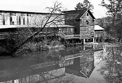 Graham's most recognizable landmark was Butler's Mill, a cotton gin located on the Little Tallapoosa River. The mill was built in 1912 and burned down on October 17, 2016. | |
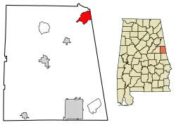 Location of Graham in Randolph County, Alabama. | |
 Graham, Alabama | |
| Coordinates: 33°27′27″N 85°19′15″W / 33.45750°N 85.32083°W | |
| Country | United States |
| State | Alabama |
| County | Randolph |
| Area | |
| • Total | 5.85 sq mi (15.16 km2) |
| • Land | 5.85 sq mi (15.16 km2) |
| • Water | 0.00 sq mi (0.00 km2) |
| Elevation | 1,102 ft (336 m) |
| Population (2020) | |
| • Total | 196 |
| • Density | 33.48/sq mi (12.93/km2) |
| Time zone | UTC-6 (Central (CST)) |
| • Summer (DST) | UTC-5 (CDT) |
| Area code(s) | 256 & 938 |
| GNIS feature ID | 119207[2] |
Graham is a census-designated place and unincorporated community in Randolph County, Alabama, United States. Its population was 211 as of the 2010 census.[3]
Demographics
| Census | Pop. | Note | %± |
|---|---|---|---|
| 2020 | 196 | — | |
| U.S. Decennial Census[4] | |||
References
- ↑ "2020 U.S. Gazetteer Files". United States Census Bureau. Retrieved October 29, 2021.
- ↑ "Graham". Geographic Names Information System. United States Geological Survey, United States Department of the Interior.
- ↑ "U.S. Census website". United States Census Bureau. Retrieved May 14, 2011.
- ↑ "Census of Population and Housing". Census.gov. Retrieved June 4, 2016.
Municipalities and communities of Randolph County, Alabama, United States | ||
|---|---|---|
| City | 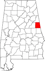 Map of Alabama highlighting Randolph County | |
| Towns | ||
| CDPs | ||
| Unincorporated communities | ||
This article is issued from Wikipedia. The text is licensed under Creative Commons - Attribution - Sharealike. Additional terms may apply for the media files.